

St. Marys River Biodiversity Atlas
The St. Marys River (SMR) serves as an international border between Michigan's Upper Peninsula and Canada's Province of Ontario, and the only connection between Lake Superior and Lake Huron. The St. Marys River extends approximately 70 miles in length from the head of the river at Whitefish Bay near Point Iroquois, downstream to De Tour Passage.
In 1988, the SMR (on both sides of the border) was identified as one of the first Areas of Concern (AOC) in the Great Lakes due to severe impacts on water quality and river sediment from various industrial activities. Since 1988, agencies and organizations on both sides of the border have worked to improve the health of the river. Despite these legacy impacts, the SMR system and its adjacent coastal zone is still considered to be one of the most biologically important regions in the Great Lakes Basin.
A key obstacle to the long-term sustainability of this biologically significant region is the lack of awareness and accessibility to high quality information about the region’s unique natural assets. The St. Marys River Biodiversity Atlas was developed to address this need. It consists of three different components: 1) an online interactive mapping tool of the region, including downloadable data layers, 2) a series of interconnected Story Maps that provide content about the St. Marys River system, and 3) a searchable catalog of written materials about the region. Combined, the goal of the Atlas is to effectively deliver information about biodiversity within the SMR AOC, and engage local citizens, visitors, decision-makers, and agencies in the long-term conservation and restoration of the area’s most significant natural features.
St. Marys River Interactive Map
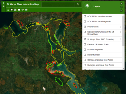
Explore maps of islands, biodiversity hotspots, land cover, natural communities, invasive species, coastal wetlands and more!
St. Marys River Biodiversity Atlas
Find great information, maps and images of the St. Marys River Area of Concern including human history, wildlife, priority natural areas, key challenges, organizations in the region and more!
Library
A searchable catalog of written materials about the region.
Credits
These resources were created by staff of the Michigan Natural Features Inventory (MNFI), a program of Michigan State University Extension MSUE). John Paskus served as the Primary Investigator and Project Manager of the project. Team members involved in the project included: Peter Badra, Daria Hyde, Helen Enander, Kraig Korroch, Yuman Lee, Rebecca Rogers and Clay Wilton. Funding was provided by the Michigan Office of the Great Lakes (OGL).
| Link | Item type | Subject | Pub. Year | Author | Title | Abstract Note |
|---|---|---|---|---|---|---|
| Link | Newspaper Article | Birds | 2018 | Freedman, Eric | Black tern numbers plummet, invasives largely to blame | The once-abundant black tern is far less abundant in Great Lakes wetlands, a victim of habitat loss and invasive plant species. And there's a high risk that more colonies will be abandoned, according to a new study. |
| Link | Report | State of the Great Lakes Report | 2018 | MI Office of the Great Lakes | MIchigan State of the Great Lakes 2017 | In this volume of the State of the Great Lakes Report, we have tried to capture a glimpse of the work that is underway in the State and region to restore, recreate, and reinvigorate our Great Lakes waters. Within this volume is a sampling of what progress in the Great Lakes looks like through the lens of shared governance. Michigan alone does not manage or maintain this vast system. We work through a complex set of relationships with federal, state, local, and regional institutions. The Great Lakes Commission, International Joint Commission, Great Lakes Fisheries Commission, Great Lakes Protection Fund, and so many others are leading initiatives in this essential work. |
| Link | Journal Article | Birds | 2017 | Wyman, Katherine; Cuthbert, Francesca | Black tern (Chlidonias niger) breeding site abandonment in U.S. Great Lakes coastal wetlands is predicted by historical abundance and patterns of emergent vegetation | Breeding colonies of black terns (Chlidonias niger) have become increasingly rare in U.S. Great Lakes coastal wetlands since the mid-twentieth century, with an almost 90% decline in the number of active colony sites since 1991. Although the specific causes of this wetland species' decline are unknown, habitat loss and degradation are thought to be a major barrier to conservation. Using data from the Great Lakes Colonial Waterbird Survey, we took a unique regional and historical approach to investigate the relationship between black tern colony site abandonment and a suite of local and landscape-scale habitat features in U.S. Great Lakes coastal wetlands. We employed logistic regression models and a combination of stepwise selection procedures to identify the best predictive model for black tern colony abandonment. According to the selected model, breeding colonies with fewer nests were more likely to be abandoned over the following decadal observation period than breeding colonies with more nests. Colony sites were also more likely to be abandoned when vegetation within the wetland shifted towards larger, denser clusters. We performed a simulation study that showed that failing to account for association between observations from the same site affected model selection results, but that cross-validation error for the selected model remained low unless site effects were very strong. Results of this study suggest that focus on protection of sites harboring large numbers of black terns and vegetation management will help limit further colony abandonments. |
| Link | Newspaper Article | Fish | 2017 | Dnr Joins in Multiagency Survey of St. Marys River Fish Community | “The purpose of the study is to gauge the health and status of the various fish populations in the river,” said David Fielder, one of the fisheries research biologists leading the DNR’s portion of the study. “Target species of importance to the researchers include walleye, yellow perch, smallmouth bass, northern pike, lake sturgeon and cisco, along with any invasive species.” | |
| Link | Report | Planning_Lake Michigan Islands | 2017 | Management Plan for State-owned Lands on Northern Lake Michigan Islands | Several recent efforts have highlighted the need to examine state land management on Lake Michigan islands and formulate an approach for effective management of these unique resources in the future. The Department of Natural Resources (DNR or the Department) recognizes that state land management actions can have social, economic, and ecological impacts within and beyond state land borders. In addition, actions on lands adjacent to state land can have similar effects. Based on these relationships, the DNR has undertaken a collaborative approach to developing this plan. The purpose of this plan is to provide a vision and intended actions for the future management of state owned lands on northern Lake Michigan islands, in partnership with local units of government, tribal governments, and other interested stakeholders. | |
| Link | Document | Water Trails | 2017 | Land Information Access Association | Michigan Water Trails Manual | This Water Trail Manual is intended to provide local officials, water advocacy organizations, paddlers and visionary citizens with the resources and tools to develop a water trail in their community. Given the rich diversity of paddling experiences in Michigan, each water trail planning effort will be unique. This manual will help you develop a water trail that is tailored to your community's capacity, resources and needs. |
| Link | Report | AOC_BUI | 2016 | Removal Recommendation Eutrphication or Undesirable Algaw Beneficial Use Impairment SMR AOC | The Michigan Department of Environmental Quality (MDEQ), Office of the Great Lakes, Areas of Concern (AOC) Program recommends the removal of the Eutrophication or Undesirable Algae Beneficial Use Impairment (BUI) from the U.S. side of the St. Marys River AOC, based on the review of relevant documentation and in accordance with the process and criteria set forth in the Guidance for Delisting Michigan's Great Lakes Areas of Concern (Guidance) (MDEQ, 2015). This recommendation is made with the support of the St. Marys River Binational Public Advisory Council (BPAC) and staff from the United States Environmental Protection Agency (U.S. EPA), Great Lakes National Program Office. | |
| Link | Report | AOC_BUI | 2016 | Removal Recommendation Beach Closing Beneficial Use Impairment SMR AOC | The Michigan Department of Environmental Quality (MDEQ), Office of the Great Lakes, Areas of Concern (AOC) Program recommends the removal of the Beach Closings Beneficial Use Impairment (BUI) from the U.S. side of the St. Marys River AOC, based on the review of relevant documentation and in accordance with the process and criteria set forth in the GUidance for Delisting Michigan's Great Lakes Areas of Concern (guidance) (MDEQ, 2015). This recommendation is made with the support of the St. Marys River Binational Public Advisory Council and staff from the united States Environmental Protection Agency (EPA), Great Lakes Nationl Program Office. | |
| Link | Report | AOC_BUI_Env. Assessment | 2016 | St. Marys River Area of Concern: Costal Wetland Habitat Assessment Report | ||
| Link | Webpage | Birds | 2016 | IBA:Rudyard Clay Plain | ||
| Link | Webpage | Birds | 2016 | Kirtland's Warbler Management Units & Guide's Rest | ||
| Link | Webpage | Birds | 2016 | Tahquamenon Falls State Park & Munising Moraine IV LTA | ||
| Link | Webpage | Birds | 2016 | Sault Sainte Marie Clay Plain | ||
| Link | Webpage | Birds | 2016 | Raco Plains & Wilwin Wetland | ||
| Link | Report | Environmental Assessment_Water Quality | 2016 | Ginou, Carrie | Water Quality Monitoring and Analysis: An investigation of the Eutrophication and Undesirable Algae, and Degradation of Aesthetics Beneficial Use Impairments in the Canadian St. Marys River Area of Concern (2013-2015) | The St. Marys River is an identified Area of Concern, where ongoing remedial actions have contributed towards its restoration. During this 3 year (2013-2015) water quality monitoring and analysis project, scientific data was collected to aid in the process of re-assessing the status of the Eutrophication and Undesirable Algae, and Degradation of Aesthetics beneficial use impairments. Field work, involving monitoring aesthetic, physical, and chemical parameters at 5 sites within the Canadian St. Marys River Area of Concern, was conducted on a total of 23 dates from November 2013 to October 2015. Analysis of the monitoring data confirms that the conditions that originally led to the beneficial uses being designated as impaired no longer exist. In particular, there was no evidence of oxygen stress, large quantities of algae, or high levels of nutrients typically found in culturally-eutrophic waters. In addition, there was also an absence of characteristics associated with degraded aesthetics. There were no objectionable deposits, unnatural colour, unnatural turbidity, or unnatural odour. Any human impacts could best be categorized as localized and could not be readily associated with larger-scale industrial or municipal sources. Given the weight of evidence from the 3 years of monitoring, it is suggested that both the Eutrophication and Undesirable Algae, and Degradation of Aesthetics beneficial use impairments, be re-designated as not impaired. |
| Link | Report | Planning_AOC_RAP | 2016 | St. Marys River, Ontario: Dredging Administrative Controls Guidance Document | The St. Marys River is a 112 km waterway bordering Canada and the United States. The river is the outflow of Lake Superior to Lake Huron, and is an important shipping channel within the Great Lakes – St. Lawrence Seaway. The St. Marys River is an Area of Concern (AOC) identified in the Canada-U.S. Great Lakes Water Quality Agreement. An AOC is a location that has experienced significant environmental degradation and impaired beneficial use. Canada and the United States have committed to developing and implementing a remedial action plan to address environmental degradation through a collaborative, scientific, and ecosystem-based approach. | |
| Link | Document | Planning_AOC_RAP | 2016 | Stage 2 Remedial Action Plan: Implementation Annex for the Canadian Waters of the St. Marys River Area of Concern | The St. Marys River was designated as one of 43 Areas of Concern under the amended Canada-U.S. Great Lakes Water Quality Agreement in 1987. Areas of Concern are sites located in the Great Lakes basin where environmental issues have resulted from a history of pollution and habitat disruption in the area. Each Area of Concern has a remedial action plan that defines the nature, extent, and causes of environmental problems and recommends actions to restore and protect the environment. Canada and Ontario work together with conservation authorities, municipalities, First Nation and Métis communities, environmental groups, industry and others to develop and implement the plans. Past pollution from industrial sources, partially treated municipal and private sewage, discharges from vessels, and untreated stormwater from the surrounding watershed are factors that have historically contributed to the degradation of the St. Marys River. Urban development and alterations to the river and its shoreline have also had an impact. The St. Marys River was designated an Area of Concern because of the cumulative negative effects this was having on fish and wildlife populations and habitat, sediment quality, and water quality. Steady progress has been made in restoring and better protecting the environment of the St. Marys River. The river is much healthier today compared to when it was first designated an Area of Concern. Investments in remedial actions and stricter environmental controls by government, along with considerable improvements in wastewater treatment made by the City of Sault Ste. Marie and local industry, have led to significant improvements in the river's water quality. In the 1990s, the federal government passed environmental legislation for pulp and paper effluents, and the provincial government introduced regulations under the Environmental Protection Act. Today, all municipal and industrial effluents must meet strict requirements and cannot be lethal to fish or aquatic insects. Wastewater effluents entering the river currently meet all provincial and federal regulations for suspended solids, biochemical oxygen demand, phosphorus, phenol, toluene, coliform and toxicity. In 2006, with financial assistance from Canada and Ontario, the City of Sault Ste. Marie upgraded its East End Wastewater Treatment Plant featuring the first biological nutrient removal system in Ontario and ultraviolet disinfection. The result has been improved effluent quality with a reduction in suspended solids by 89%, phosphorus by 91%, and biological oxygen demand (BOD) by 96%. Significant reductions in nitrogen and ammonia have also been achieved. Since 1987, Essar Steel Algoma Inc. (formerly Algoma Steel Inc.) has reduced the amount of oil and grease entering the river via wastewater by 96%. They have also reduced suspended solids by 94%, phenols by 99%, and ammonia by 95%. As of 2012, the St. Marys Paper plant has been decommissioned and the site dismantled, therefore there is no wastewater discharge to the river. That being said, efforts made in previous years had significantly reduced contaminants in the mill's wastewater. Between 1995 and 2006, the installation of an activated sludge secondary treatment facility reduced suspended solids by 91%, biological oxygen demand (BOD) by 97%, and odour-causing phenols by 95%. While inputs of pollution into the river are no longer as severe as they used to be, the legacy of harmful activities has left many environmental challenges that still need to be addressed. | |
| Link | Report | AOC_BUI_Beach Closures | 2015 | Belleau, Angela; Barrett, Corrina; Ginou, Carrie | An Assessment of the Ontario St. Marys River Aera of Concern Beach Closures Beneficial Use Impairment | In 1985, the International Joint Commission (IJC) identified the St, Marys River as one of 43 Aeras of Concern (AOC) in teh Great Lakes (St. Marys River Stage 1 1992). Being an international waterway, the area was designated a binational area of concern under the Great Lakes Water Quality Agreement (GLWQA) in 1987 between Canada and the united States. As outlines in the GLWQA (1987), an AOC is a geographic area that is designated by Parties based on the impairment of beneficial uses that occured as a result of human activity. The agreement was amended in 2012 and reaffirms the commitment made by both countries to develop and implement a Remedial Action PLan (RAP) for the St. Marys River by taking a collaborative, scientific, and ecosystem-based approach. . .This report will only address the Beach Closures BUI. It specifically addresses questions brought up by the BPAC regarding high incidences of E. coli and associated beach postings at Marks Bay and other AOC beaches. The report provides an overview for why the BUI was originally deemed impaired in teh St. Marys River, how delisting criteria were developed and what the current status is of the Beach Closures BUI. |
| Link | Report | AOC_BUI_Env. Assessment | 2015 | St. Marys River Area of Concern: Coastal Wetland Habitat Assessment Report | The St. Marys River is a 112 km connecting channel between Lake Superior and Lake Huron. In 1985, the International Joint Commission (IJC) identified the St. Marys River as one of the 43 Areas of Concern (AOC) on the Great Lakes. The condition of wildlife populations, a subcomponent under Beneficial Use Impairment (BUI) #3 (Degradation of Fish and Wildlife Populations), is currently listed as “requires further assessment” while BUI #14 (Loss of Fish and Wildlife Habitat) is currently listed as “impaired”. Given that coastal wetlands provide a number of functions as well as wildlife habitat, it is important to gain a better understanding of their current state within the AOC and surrounding area. Building upon work started in 2012 (see Environment Canada, 2013), a subset of coastal wetlands in the St. Marys River, both within and outside the AOC, were visited and surveyed for water quality, submerged aquatic vegetation, aquatic macroinvertebrates, amphibians, and marsh breeding birds in 2014 to assess the condition of coastal wetland habitat and biotic communities. Using the Water Quality Index (WQI), water quality within St. Marys River coastal wetlands ranged from very degraded to very good, with the majority of sites ranked in good condition. Water quality in AOC versus non-AOC wetlands was similar. The degradation of water quality appears to be primarily a result of increased turbidity. An Index of Biotic Integrity (IBI), which is a multimetric index indicating the ability of a habitat to support and maintain a balanced, integrated, adaptive biological system having the full range of elements expected in a region's natural habitat, is being developed for each of submerged aquatic vegetation (SAV), macroinvertebrates, marsh birds and amphibians. The potential SAV IBIs developed for the St. Marys River showed variation among sites, although a difference in AOC versus non-AOC sites was observed. Sites in the AOC ranged from poor to excellent, having both the highest and lowest scores recorded in 2014, while non-AOC sites ranged from fair to excellent. The potential aquatic macroinvertebrate IBI showed variation in AOC versus non-AOC sites, with sites in the non-AOC ranking in the good category while AOC sites ranged from poor to excellent. Marsh breeding bird communities had area-sensitive marsh-nesting obligate species at only two sites: Echo Bay and Lake George. The potential IBIs developed for the marsh bird community rank these two AOC sites in the best condition while non-AOC sites are ranked as poor or fair. The amphibian community in the St. Marys River did not respond well to the disturbance gradients assessed for development of an IBI, and therefore more monitoring is required before a suitable IBI can be established. The IBIs used in this report require validation before they can be used to report on the status of BUI # 14. Nonetheless, progress is being made to aid in providing empirical information to support the assessment of the Loss of First and Wildlife Habitat BUI for the St. Marys River AOC. | |
| Link | Webpage | AOC_BUI_restoration timeline | 2015 | US EPA, REG 05 | Restoring St. Marys River AOC (timeline) | Timeline of restoration activities at St. Marys River AOC. |
| Link | Document | AOC_Facts | 2015 | SMR AOC Fact Sheet 2015 | ||
| Link | Map | AOC_Facts_Sediment Maps | 2015 | SMR Sediment Map Metals | ||
| Link | Map | AOC_Sediment Maps | 2015 | SMR Sediment Maps Total PAH | ||
| Link | Report | Enviornmental Assessment_Water Quality | 2015 | Ginou, Carrie | Water Quality Monitorying and Analysis for the St. Marys River Area of Concern Technical Report (2014-2015) | The St. Marys River is an identified Area of Concern, where ongoing remedial actions have contributed towards its restoration. In the second year of a three-year (2013-2016) water quality monitoring and analysis project, progress was made in the process of re-assessing the status of the Eutrophication and Undesirable Algae and Degradation of Aesthetics beneficial use impairments. Field work, involving monitoring aesthetic, physical and chemical parameters at 5 sites within the Canadian St. Marys River Area of Concern, was conducted on 11 dates from May to October 2014. Analysis of the monitoring data suggests that the conditions that originally led to the beneficial uses being designated as impaired no longer exist. In particular, there was no evidence of oxygen stress, large quantities of algae, or high levels of nutrients typically found in culturally-eutrophic waters. In addition, there was also an absence of characteristics associated with degraded aesthetics. There were no objectionable deposits, unnatural colour, unnatural turbidity, or unnatural odour. Any human impacts observed could best be attributed to localized recreational activities and could not be readily associated with larger-scale industrial or municipal sources. Future work includes monitoring during the 2015 field season and collecting additional data to inform the final decision-making process about the status of the Eutrophication and Undesirable Algae and Degradation of Aesthetics beneficial use impairments. |
| Link | Presentation | Environmental Assessment | 2015 | Darwin, Angela | Assessing Coastal Wetland Habitat Condition on the Canadian side of the St. Marys River Area of Concern | |
| Link | Report | Environmental Assessment_Sediment analysis | 2015 | RTI Laboratories, Inc. | SMR Federal Navigation Channel Sediment Sampling and Analysis Report | The U.S. Army Corps of Engineers, Detroit District (USACE) retained RTI Laboratories, Inc. (RTI) as a contractor to perform sediment sampling services within the Federal Navigation channels of the Thunder Bay River in Alpena, Michigan (Site) in response to and in accordance with the Detroit District's Request for Proposal (RFP) and Statement of Work (SOW) received on 24 July 2014 and modified on 30 December 2014. This project is part of an assessment of sediment quality within the navigation channel of the site. This project involves collection of sediment samples from shoaling within the Navigation Channel of the River. This information will be used by the District and its clients to select the proper sediment dredging practices as well as monitor any potential migration of contaminants. RTI provided sediment sampling services using both Gravity-core sampling devices mounted on a V-hulled boat and Macro-core sampling using a push type coring device mounted on a pontoon boat and barge at this Site. |
| Link | Blog Post | Island_Whitefish Island History | 2015 | Public Spaces and Indigenous Land: Whitefish Island | Whitefish Island is both First Nation territory, a national historic site, and a space that is frequently accessed by the public. Additionally, the nature of the island as a traditional meeting place and place of Anishinaabe settlement has resulted in it being deemed an important archaeology site. The high volume of visitors combined with a lack of public understanding about the nature of the site have resulted in some vandalism, damage to the site, and loss of artifacts from the island. | |
| Link | Report | Planning_AOC_RAP | 2015 | Stage 2 Remedial Action Plan Implementation Annex for the Canadian Waters of the St. Marys River Area of Concern | The St. Marys River was designated as one of 43 Areas of Concern under the amended Canada-U.S. Great Lakes Water Quality Agreement in 1987. Areas of Concern are sites located in the Great Lakes basin where environmental issues have resulted from a history of pollution and habitat disruption in the area. Each Area of Concern has a remedial action plan that defines the nature, extent, and causes of environmental problems and recommends actions to restore and protect the environment. Canada and Ontario work together with conservation authorities, municipalities, First Nation and Métis communities, environmental groups, industry and others to develop and implement the plans. Past pollution from industrial sources, partially treated municipal and private sewage, discharges from vessels, and untreated stormwater from the surrounding watershed are factors that have historically contributed to the degradation of the St. Marys River. Urban development and alterations to the river and its shoreline have also had an impact. The St. Marys River was designated an Area of Concern because of the cumulative negative effects this was having on fish and wildlife populations and habitat, sediment quality, and water quality. Steady progress has been made in restoring and better protecting the environment of the St. Marys River. The river is much healthier today compared to when it was first designated an Area of Concern. Investments in remedial actions and stricter environmental controls by government, along with considerable improvements in wastewater treatment made by the City of Sault Ste. Marie and local industry, have led to significant improvements in the river's water quality. In the 1990s, the federal government passed environmental legislation for pulp and paper effluents, and the provincial government introduced regulations under the Environmental Protection Act. Today, all municipal and industrial effluents must meet strict requirements and cannot be lethal to fish or aquatic insects. Wastewater effluents entering the river currently meet all provincial and federal regulations for suspended solids, biochemical oxygen demand, phosphorus, phenol, toluene, coliform and toxicity. In 2006, with financial assistance from Canada and Ontario, the City of Sault Ste. Marie upgraded its East End Wastewater Treatment Plant featuring the first biological nutrient removal system in Ontario including UV light for disinfection. The result has been improved effluent quality with a reduction in suspended solids by over 89%, phosphorus levels by more than 91%, and biological oxygen demand (BOD) by over 96%. Significant reductions in nitrogen and ammonia have also been achieved. Since 1987, Essar Steel Algoma Inc. (formerly Algoma Steel Inc.) has reduced the amount of oil and grease entering the river via wastewater by more than 96%. They have also reduced suspended solids by over 94%, phenols by more than 99%, and ammonia by over 95%. As of 2012, the St. Marys Paper plant has been decommissioned and the site dismantled, therefore there is no wastewater discharge to the river. That being said, efforts made in previous years had significantly reduced contaminants in the mill's wastewater. Between 1995 and 2006, the installation of an activated sludge secondary treatment facility reduced suspended solids by over 91%, biological oxygen demand (BOD) by more than 97%, and odour-causing phenols by over 95%. While inputs of pollution into the river are no longer as severe as they used to be, the legacy of environmentally harmful activities has left many environmental challenges that need to be addressed | |
| Link | Report | Planning_Biodiversity Conservation Strategy_Lake Superior | 2015 | Lake Superior Binational Program | A Biodiversity Conservation Strategy for Lake Superior A Guide to Conserving and Restoring the Health of the World's Largest Freshwater Lake | The Lake Superior Biodiversity Conservation Strategy has been developed to guide and support actions necessary to restore and protect Lake Superior's habitats and species. It has been prepared over a period of two years by the Lake Superior Binational Program with communication with or input from nearly 600 experts and stakeholders. The Lake Superior Biodiversity Conservation Strategy was started in 2012, with the assessment of key conservation targets and threats. These targets and threats helped identify strategies to conserve Lake Superior's habitats and species. In addition to the lakewide strategies that are provided in this document, 20 regional plans have been prepared for areas around the lake (Figure 1). These regional plans identify key local actions that support the conservation and restoration of Lake Superior within the context of broader, lakewide objectives. Regional plans, the biodiversity assessment, and details on the planning process can be found on the project website at: www.natureconservancy.ca/superiorbca |
| Link | Document | Planning_Munuscong State Wildlife Area | 2015 | MDNR | Munuscong State Wildlife Management Area Management Plan | The Michigan Department of Natural Resources (Department) has the primary responsibility and statutory authority for the management of resident wildlife, fish, and state forest land in Michigan. This management plan (Plan) was developed to guide the Department's management of state forest, wildlife, and related public trust natural resources in the Munuscong State Wildlife Management Area. Partnerships with other agencies and organizations have been important for management of this area in the past, and will be increasingly important in the future |
| Link | Report | AOC_BUI | 2014 | Removal Recommendation Degradation of Aesthetics Beneficial Use Impairment St. Marys River Area of Concern | The following description is paraphrased from the 1992 Remedial Action Plan (RAP) update, discussing specific aesthetic problems at the time: the Degradation of Aesthetics BUI was impaired in the St. Marys River as a result of nuisance levels of floating material being periodically reported along the north shore of Sugar Island in the Lake George Channel (OMOE and MDNR, 1992). In addition to nuisance floating material, the East End Waste Water Treatment Plan (WWTP) and Algoma Steel were identified as major point sources contributing to over 88 percent of the oil and grease to the river, followed by St. Marys Paper (EC et al., 2002). The Chippewa County Health Department (CCHD) and the St. Marys River Binational Public Advisory Council (BPAC) have repeatedly expressed concern regarding sanitary trash washing up on the Sugar Island Township Park beach following wet weather events. Those materials may be originating from the East End WWTP in Sault Ste. Marie, Ontario, as a result of bypasses when the plant is inundated and unable to fully treat the volume of water it receives following significant rain storms. The material may also be litter form storm water run-off and/or discharges from the storm sewer system. | |
| Link | Report | AOC_BUI_ Bird/Animal deformaties | 2014 | Huges, K.D.; Crump, D.; Williams, K.; Martin, P.A. | Assessment of the Wildlife Reproduction and Deformities Beneficial Use Impairment in the St. Marys River Area of Concern (Ontario) | Reproduction and development were examined in herring gulls (Larus argentatus) and common terns (Sterna hirundo) breeding within the St. Marys River Area of Concern (Ontario) in 2011 and 2012. Freshly-laid eggs were collected from colonies within the Area of Concern (AOC) as well as outside of the AOC, artificially incubated in the laboratory and assessed for embryonic viability, incidence of embryonic deformities, contaminant burdens and other biochemical endpoints. Productivity was determined at the colonies when chicks were > 21 days old and chicks were examined for morphological deformities as well as other biological endpoints. Overall, embryonic viability of herring gulls and common terns was high at AOC colonies and herring gull productivity at AOC colonies was within the range required to maintain a stable population. Common tern productivity at AOC colonies, while low, was consistent with rates for common terns within the region and was largely attributable to external stressors, such as predation and severe weather events. No morphological deformities were found in field surveys of juveniles of either species (based on sample sizes of 13-63 chicks); however, a low incidence of embryonic deformities (i.e., 4-8% based on sample sizes of 15-30 embryos) was observed for both species collected from AOC colonies and artificially incubated in the lab. The significance of this finding is unknown at this time. Comparable burdens of non-ortho PCBs, 2,3,7,8-TCDD, and TEQs between deformed and normal embryos from AOC colonies of both species rule out the possibility that embryonic deformities were associated with elevated exposure to these compounds. Importantly, contaminant burdens (e.g., PCBs, 2,3,7,8-TCDD, and mercury) in gull and tern embryos from the St. Marys River AOC (Ontario) were comparable and not notably elevated compared to burdens at respective reference colonies in the two study years. Finally, concentrations of PCBs, other organochlorines, PBDEs, dioxins/furans and mercury were not sufficiently elevated in embryos to adversely impact the reproductive success and development of herring gulls and common terns foraging in the St. Marys River AOC. |
| Link | Document | AOC_Facts | 2014 | Great Lakes Area of Concern | The Government of Canada has contributed millions to support local action to clean up Areas of Concern since 1987. In Budget 2010, the Government of Canada renewed and made permanent its funding of $8 million per year for this work, and a further $48.9 million was allocated by the Government of Canada to address the problem of remediation of contaminated sediments. | |
| Link | Journal Article | Birds | 2014 | Hughes, K.D.; Moore, D.J.; Martin, P.A. | An Assessment of Breeding Populations of Common Terns and Black Terns in the St. Marys River Area of Concern (Ontario) | The purpose of this summary is to report on the results of recent assessments of breeding populations of Common Terns (Sterna hirundo) and Black Terns (Chlidonias niger) within the St. Marys River Area of Concern (AOC) (Ontario) following the recommended action put forward in the Stage 2 Remedial Action Plan report (Environment Canada et al. 2002). These assessments are based on nest count surveys conducted in the AOC and are supplemented with historical breeding data for these species where available. Population trends for other colonial waterbirds based on decadal surveys are also reported to provide a broader historical context of trends in diversity and abundance of breeding colonial waterbirds in the St. Marys River AOC. |
| Link | Report | Enviornmental Assessment_Climate Change_Lake Superior | 2014 | Battelle | Lake Superior Climate Change Impacts and Adaption | Changing climate conditions will impact efforts to protect and restore Lake Superior. Current observations in the Lake Superior basin demonstrate that some changes in climate are already occurring, including increases in surface water and air temperatures and a decrease in the extent and duration of ice cover. Projected climate changes could have a range of future potential effects on Lake Superior ecosystems, including a decrease in the abundance of cold water fish and changes to coastal wetlands. This report synthesizes available science and identifies adaptation strategies and actions for Lake Superior ecosystems. The report provides a structure to track and share climate science related to Lake Superior and outlines potential climate change adaptation strategies and actions that can be implemented in the future. The report focuses specifically on adaptation of Lake Superior ecosystems and does not discuss impacts related to human infrastructure. Similarly, the report does not identify climate change mitigation actions (i.e., greenhouse gas [GHG] emission reductions), but rather serves as a regional resource for complementary initiatives that are promoting the importance of reducing GHG emissions. Projected climate changes are determined from the output of general circulation models (GCMs), which simulate changes in climate under scenarios of future GHG emissions. While specific changes may vary by location, a range of plausible future climate conditions is projected for the Lake Superior region during the 21st century. |
| Link | Report | Enviornmental Assessment_Water Quality | 2014 | Ginou, Carrie | Water Quality Sampling and Analysis for the St. Marys River Area of Concern (Beneficial Use Impairment Assessment) | The St. Marys River is a major channel in the Great Lakes system connecting Lake Superior to Lake Huron and separating the twin cities of Sault Ste. Marie, Ontario and Michigan. As a result of water quality deteriorating, to a point where threats to wildlife populations and human activities were recognized, the St. Marys River was officially designated as an Area of Concern (AOC) in the 1980s. This designation led to remediation measures including the development of Remedial Action Plans (RAPs). Through the RAP process, a list of beneficial use impairments (BUIs) was identified for the St. Marys River AOC. Some of those BUIs remain a problem and others have been significantly improved through regulatory changes and infrastructure projects. The purpose of this three-year project is to collect and analyze water quality data and review relevant literature in order to re-assess the status of two beneficial use impairments, (1) eutrophication or undesirable algae and (2) degradation of aesthetics, for the Canadian portion of the St. Marys River Area of Concern. The main tasks accomplished towards this purpose in Year 1 (2013-2014) were: selecting five field sites, choosing an analytical laboratory, developing water quality sampling protocols, formulating worker safety and emergency response plans, doing preliminary water quality sampling, performing data analysis and reporting on initial results. The sampling sites selected within the St. Marys River spanned the length of the AOC and were at locations identified as being either at the source or mouth of the river or at locations which were previously known to be impacted by the BUIs of interest. They are, from North-West to South-East: Gros Cap, Bellevue Park, Bell's Point, Echo Bay and Richards Landing. Parameters measured at each site were geared to the BUIs of interest and included: water clarity, colour and odour, visible debris, obvious pollution, algae, nutrients (ammonia, nitrite, nitrate, nitrogen and phosphorus), chlorophyll a, pH, dissolved oxygen, dissolved organic carbon, total suspended solids and turbidity. Preliminary results suggest that the sampling sites chosen and protocols developed were successful and should be used in subsequent project years. Analysis of the initial water quality data indicates that there are limited signs of (1) eutrophication or undesirable algae at the Echo Bay site and minor indications of (2) degradation of aesthetics at both the Bellevue Park and Echo Bay sampling sites. Further study in project years 2-3 should help to clarify if the beneficial uses remain impaired. |
| Link | Report | Environmental Assessment_Climate Change_Lake Superior | 2014 | Huff, A.; Thomas, A. | Lake Superior Climate Change Impacts and Adaptation | This report synthesizes available science and identifies adaptation strategies and actions for Lake Superior ecosystems. The report provides a structure to track and share climate science related to Lake Superior and outlines potential climate change adaptation strategies and actions that can be implemented in the future. The report focuses specifically on adaptation of Lake Superior ecosystems and does not discuss impacts related to human infrastructure. Similarly, the report does not identify climate change mitigation actions (i.e., greenhouse gas [GHG] emission reductions), but rather serves as a regional resource for complementary initiatives that are promoting the importance of reducing GHG emissions. Projected climate changes are determined from the output of general circulation models (GCMs), which simulate changes in climate under scenarios of future GHG emissions. While specific changes may vary by location, a range of plausible future climate conditions is projected for the Lake Superior region during the 21st century. |
| Link | Journal Article | Fish | 2014 | Hudson, John C.; Ziegler, Susy S. | Environment, Culture, and the Great Lakes Fisheries * | The commercial fisheries of the United States and Canadian Great Lakes are in a long period of decline. Detailed statistics kept for well over a century document a fluctuating pattern of harvests of the major commercial species. In the 1940s, sea lamprey began to devastate the fisheries, an effect that has not been fully countered. Overfishing, nonnative species, declining nutrient levels, and chemical pollution have contributed to reduced catches. Court decisions in the United States and Canada during the past thirty years have awarded a sizable share of commercial fishing rights to Native North Americans for their own support and sustenance. The Lake Erie yellow perch and walleye fishery, based mainly in Ontario, is the most successful commercial fishing operation in the region. Despite the many environmental and cultural challenges, the Great Lakes fisheries live on. |
| Link | Journal Article | Fish | 2014 | Tucker, Stefan; Moerke, Ashley; Steinhart, Geoffrey; Greil, Roger | NOTE: First record of natural reproduction by Atlantic salmon (Salmo salar) in the St. Marys River, Michigan | Atlantic salmon (Salmo salar) are native to Lake Ontario; but their populations severely declined by the late 1800s due to human influences. During the early to mid-1900s, Atlantic salmon were stocked throughout the Great Lakes in effort to reestablish them into Lake Ontario and introduce the species into the upper Great Lakes. However, these efforts experienced minimal success. In 1987, Lake Superior State University and the Michigan Department of Natural Resources began stocking Atlantic salmon in the St. Marys River, Michigan, which has resulted in a successful, self-supporting hatchery operation and stable recreational Atlantic salmon fishery. Possibly due to a combination of competition with other salmonid species for spawning habitat, prey selection causing detrimental effects on early life stages and high rates of early mortality syndrome, Atlantic salmon appeared to be severely limited in their ability to naturally reproduce within the upper Great Lakes. In 2012, the first unequivocal documentation of naturally reproduced Atlantic salmon in the St. Marys River was recorded, downstream from the compensation works and parallel to the Soo Locks in Sault Ste. Marie, Michigan. |
| Link | Journal Article | Invasive Species_ Sea lamprey | 2014 | Robinson, Jason M.; Wilberg, Michael J.; Adams, Jean V.; Jones, Michael L. | Comparing methods for estimating larval sea lamprey (Petromyzon marinus) density in the St. Marys River for the purposes of control | The St. Marys River is a major producer of parasitic sea lampreys (Petromyzon marinus) to Lake Huron making it an important area for larval control. Bayluscide treatments are conducted in areas of high larval density requiring density estimation at fine spatial scales to inform treatment decisions. We evaluated six methods of estimating spatially specific density including the currently used sampling-based estimates, a generalized linear model (GLM) based on mean larval density per plot, a GLM based on larval density per sample, a generalized additive model based on mean larval density per plot, a spatial age-structured population model, and a hybrid approach, which averaged the best performing sampling- and model-based methods. Methods were evaluated based on accuracy in matching independent validation data. Specifically, the methods were evaluated based on their ability to project plot-level larval density, identify high density plots for treatment, and rank plots in order based on density resulting in high numbers of sea lampreys killed per hectare treated. Performance was variable, and no single method outperformed the others for all metrics. Although the sampling-based estimation method and the GLM based on catch data performed adequately for estimating density and identifying high density plots, the hybrid approach was identified as the best method to inform sea lamprey control decisions in the St. Marys River due to its consistent performance. Incorporating model-based approaches should lead to a more efficient and effective treatment program in the St. Marys River and aid in making decisions about the allocation of control resources. |
| Link | Report | Invasive Species_Plan | 2014 | The Lake Superior Work Group of te Lake Superior Lakewide Action and Management Plan | Lake Superior Invasive Species Complete Prevention Plan | Situated at the head of the Great Lakes St. Lawrence Seaway system, a 2,342 mile long (3,700 km) water navigation system connected to global trade, Lake Superior is at risk for continued invasion by aquatic invasive species (AIS), including plants, animals, and microscopic organisms. As of April 2010, 89 non-native aquatic species have been found in Lake Superior. These include Eurasian watermilfoil, sea lamprey, and most recently, the fish disease Viral Hemorrhagic Septicemia (VHS). AIS have caused devastating economic and ecosystem effects that impart significant losses to the region in the form of damage and control costs, degraded water quality, job losses, declining property values, compromised native species, decreased biodiversity, and other negative impacts. This Lake Superior Aquatic Invasive Species Complete Prevention Plan outlines recommended actions that need to be newly implemented, in addition to existing efforts, to prevent new aquatic invasive species from entering and becoming established in the Lake Superior ecosystem. Through the process of developing this plan, Canadian and U.S. government agencies involved in the Lake Superior Lakewide Action and Management Plan (LAMP) have consulted broadly and have developed recommendations for consideration by each jurisdiction. However, citizens, organizations and government agencies in both Canada and the United States need to work together to implement the recommended actions and ensure that protecting Lake Superior from new invasive species is a top priority for all. The Lake Superior LAMP will utilize an adaptive management approach to monitoring implementation progress and overall effectiveness of this prevention plan. |
| Link | Report | AOC | 2013 | Environment Canada | St. Marys River Area of Concern: Coastal Wetland Habitat Scoping Report | Given coastal wetlands provide a number of functions including wildlife habitat, it is important to gain a better understanding of their current state within the AOC as well as the surrounding area. In 2012, a subset of coastal wetlands in the St. Marys River, both within and outside the AOC, were visited and surveyed for water quality, submerged aquatic vegetation, and marsh breeding birds in order to assess the condition of coastal wetland habitat and biotic communities. |
| Link | Report | AOC_Facts | 2013 | St Marys River Area of Concern Fact Sheet Update (2013) | ||
| Link | Report | Birds and Bats | 2013 | Peterson, Anna; Horton, Rebecca | Using Acoustic and Ultrasonic Monitors to Document Bird and Bat Presence along the Great Lakes Coastlines during the 2012 Spring and Fall Migration Seasons | During the 2012 spring and fall migration seasons, monitors were placed near the shorelines of Lakes Michigan, Huron, Erie and Ontario to record nighttime bird and bat sounds (Spring: 32 monitors, Fall: 21 monitors) (Figure 2). In order to determine if there is a gradient of bird and/or bat density as you move inland from the lakeshore, along the west shore of Lake Michigan, additional monitors were placed inland of the near-shore sites, forming six east-west transects. Two transects include a near-shore site and a site 3 miles inland; 4 transects have sites near-shore and 3, 6 and 10 miles inland. These sites, along with sites along the north shore of Lake Michigan and the south shore of Lake Ontario, also collected data throughout the breeding season; however only data from the spring and fall migrations seasons were used in this analysis. |
| Link | Webpage | Environmental Assessment | 2013 | Environment Canada | St. Marys River Area of Concern: coastal wetland scoping report | |
| Link | Document | Planning_Munuscong River Watershed Mgt. Plan | 2013 | The Chippewa/Luce/Mackinac Conservation District (CLMCD) | Munuscong River Watershed Management Plan | The Munuscong River Watershed Management Plan is a guide to help the Eastern Upper Peninsula community and other stakeholders, including local units of government, non-profit organizations, and local residents, protect water quality and aquatic resources. It can provide a recipe of Best Management Practices (BMPs) and land use planning recommendations to correct current water quality problems and to protect water quality into the future |
| Link | Report | AOC_Facts | 2012 | St. Marys River Area of Concern Fact Sheet | ||
| Link | Report | Enviormental Assessment_Benthic Conditions | 2012 | Milani, Danielle | Benthic Conditions in the St. Marys River from 2009 to 2010 and an Overbiew from 2002 to 2010 | In 2009 to 2010, 22 stations were samples in the St. Marys River focusing on East Bellevue Marine Park (EBMP) and Lake George Channel (LGC), two potentially problematic area identified in previous studies. Increasing sampling station coverage in both EBMP and LGC provided assistance in developing a sediment management strategy for the St. marys River. Data were collected on the benthic invertebrate community structure, functional responses of benthic invertebrates using laboratoy tocivity test, and the physical and chemical attributes of the sediment and overlying water. Conditions at test sites were compared with those at Great Lakes reference sites using multivariate techniques. Relationships between tocivity and contaminant concentrations were also evaluated by regression analysis. Data were applied to the Canada-Ontario decision-making framework for contaminated sediment to determine environmental risk. This report also includes an overview of previous studies conducted in the river from 2002 to 2010, including Bellevue Marine Park, providing a comprehensive picture of conditions in the depositional areas of the river. |
| Link | Report | Planning_AOC_RAP | 2012 | Office of the Great Lakes; Great Lakes Management Unit; Michigan Department of Environmental Quality | Stage 2 Remedial Action Plan Implementation Annex for teh U.S. Waters of the St. Marys River Area of Concern | A Michigan Department of Environmental Quality (MDEQ) Stage 2 Remedial Action Plan (RAP) for each Area of Concern (AOC) is the primary tool for documenting and communicating restoration progress. The AOC-specific Stage 2 RAPs are meant to be brief, user-friendly documents that identify actions needed to restore Beneficial Use Impairments (BUIs) in each AOC. The Stage 2 RAPs are prepared by the MDEQ in consultation with the respective AOC Public Advisory Council (PAC) and the United States Environmental Protection Agency (USEPA), Great Lakes National Program Office (GLNPO). Identifying specific actions necessary to remove a BUI is one component of the MDEQ's process for tracking AOC restoration, removing BUIs, and ultimately delisting AOCs. These processes and relevant restoration criteria are described in more detail in the MDEQ's Guidance for Delisting Michigan's Great Lakes Areas of Concern (Guidance) (MDEQ, 2008). Comprehensive background information on the AOC is provided in previous RAP documents, which are listed in the reference section of this publication. |
| Link | Report | Planning_AOC_RAP | 2012 | Office of the Great Lakes; Great Lakes Management Unit; Michigan Department of Environmental Quality | Stage 2 Remedial Action Plan Implementation Annex for the U.S. Waters of the St. Marys River Area of Concern | A Michigan Department of Environmental Quality (MDEQ) Stage 2 Remedial Action Plan (RAP) for each Area of Concern (AOC) is the primary tool for documenting and communicating restoration progress. The AOC-specific Stage 2 RAPs are meant to be brief, user-friendly documents that identify actions needed to restore Beneficial Use Impairments (BUIs) in each AOC. The Stage 2 RAPs are prepared by the MDEQ in consultation with the respective AOC Public Advisory Council (PAC) and the United States Environmental Protection Agency (USEPA), Great Lakes National Program Office (GLNPO). Identifying specific actions necessary to remove a BUI is one component of the MDEQ's process for tracking AOC restoration, removing BUIs, and ultimately delisting AOCs. These processes and relevant restoration criteria are described in more detail in the MDEQ's Guidance for Delisting Michigan's Great Lakes Areas of Concern (Guidance) (MDEQ, 2008). Comprehensive background information on the AOC is provided in previous RAP documents, which are listed in the reference section of this publication. |
| Link | Document | AOC_Facts | 2011 | Statewide Public Advisory Council for; Statewide Public Advisory Council | Frequently-Asked-Questions-About-MIchigans-AOCs-2011.pdf | This document provides answers to a number of basic questions about Michigan's Great Lakes Areas of Concern program. The answers are brief and general in nature. Additional details about the overall program as well as individual Areas of Concern are available online from a number of sources. Web sites relevant for specific questions are noted, and a comprehensive list is provided at the end of the document along with contacts for each of Michigan's Areas of Concern. This document was prepared by the Statewide Public Advisory Council for Michigan's Great Lakes Areas of Concern Program in consultation with the Department of Natural Resources and Environment. For more information on the Council and Michigan's Great Lakes Areas of Concern, visit the Council's web site at www.glc.org/spac/ or contact the Council support staff at the Great Lakes Commission at 734-971-9135, SPAC@glc.org. |
| Link | Journal Article | AOC_Facts_Environmental History | 2011 | Ripley, Michael P.; Arbic, Bernard; Zimmerman, Gregory | Environmental history of the St. Marys River | This paper provides a brief history of the navigational and industrial activities that led to the St. Marys River being declared a Great Lakes Area of Concern in 1985 and serves to give context to the special issue of the Journal of Great Lakes Research devoted to the St. Marys River. Although much of the river contains important fish and wildlife habitat including mostly intact coastal wetlands, the urban areas of the upper St. Marys River have been impacted over the past 100+years by industrial and navigational development. One of the more severe impacts was the near-total destruction of the once-prolific St. Marys Rapids. Large volumes of pollution were discharged into the river including up to 10,000kg/day of oil and grease. The invasion of sea lamprey severely reduced lake trout and other fisheries. Water quality monitoring and other studies from the 1970s to 1980s documented these problems. Enforcement of environmental regulations enacted in Canada and the United States, investments in pollution control technology by industry and the municipalities, and improved fisheries management for invasive species have resulted in improved environmental conditions, however legacy impacts remain. The on-going Remedial Action Plan (RAP) process provides a framework for continued environmental improvements. |
| Link | Report | Bats | 2011 | Gehring, Joelle; Barton, Barb | Bat Migration Along the Lake Michigan and Lake Huron Coastlines: A Pilot Study To Inform Wind Turbine Siting | The rate of wind turbine construction in Michigan is expected to soar due to the high potential for wind development along the Great Lakes. Of great concern is the impact of turbines on bats, as these structures cause mortality due to both collision and decompression (barotrauma). Barotrauma accounts for as many as half the bats that are killed by wind turbines. This, coupled with white-nosed bat syndrome (WNBS), which is sweeping through bat populations in the northeast, has the potential to severely impact the presence of bats in our country, as well as our state. At least one million bats have been killed by WNBS, and the disease is rapidly spreading through the states. This project will monitor and record the presence and flight behaviors of bats and nocturnal migrant birds in association with the Lake Michigan shoreline to assess bat migration and the collision risk that wind turbines could pose to these populations. To determine the use of the coastline as migratory routes, samples will be taken from seven sites - three coastal, three located three miles inland from the coastal sites, and one island. Special equipment developed to record presence of bats and birds through radar will be used. Acoustic and ultra-frequency sampling will be analyzed to identify bat species by their call. This spatial migratory data will allow wind developers to minimize impacts to bat species. |
| Link | Journal Article | Biota | 2011 | Turschak, Benjamin A.; Moerke, Ashley H.; Evans, Barbara I. | Spatial and seasonal patterns in the crustacean zooplankton community of the St. Marys River | Zooplankton communities of the Great Lakes have received significant attention in light of recent food web changes. No recent attempts have been made, however, to characterize the zooplankton community of the St. Marys River, the sole connecting channel between Lake Superior and Lake Huron. The purpose of this study was to provide new reference information for St. Marys River zooplankton communities and discuss the patterns observed in relation to recent changes in the Great Lakes. To address these objectives, sampling occurred at Lake Superior State University's Aquatic Research Laboratory from 2003 to 2007, and at 9 coastal wetlands in 2005. Compared to historical studies of St. Marys River riverine zooplankton, relative densities of calanoid copepods and daphnids have decreased while cyclopoid copepods and bosminids have increased. Coastal wetland communities continue to be diverse and exhibit similar community structure to previous studies, although Leptodora kindti, historically an abundant nearshore taxa, is now absent. Mechanisms driving differences in present community structure as compared to that noted in past studies of the St. Marys River are unknown but may be explained by the presence of the predatory, invasive zooplankton, Bythotrephes longimanus, local environmental variables, or changes upstream in Lake Superior. Temperature–zooplankton abundance patterns and nearshore community structure of Lake Superior are reflected in the St. Marys zooplankton community; thus, local environmental factors including changes in planktivory and proximity to upstream feeder communities likely play an important role in structuring St. Marys River zooplankton communities seasonally and spatially. |
| Link | Journal Article | Environmental Assessment | 2011 | Moerke, Ashley H.; Werner, R. Marshall | ||
| Link | Journal Article | Environmental Assessment | 2011 | Keller, Barbara J.; Back, Richard C.; Westrick, Judy; Werner, Marshall; Evans, Barbara; Moerke, Ashley; Zimmerman, Greg; Wright, Derek D.; Grenfell, Emily; Courneya, Johnna | Sediment quality at select sites in the St. Marys River Area of Concern | The St. Marys River is the sole surface outlet from Lake Superior, flowing over 100km to Lake Huron, and forming part of the international border between Canada (Ontario) and the United States (MI). The river system has been severely impacted by modifications to the hydrology as well as local industrial and municipal discharges, and was designated in 1985 as an Area of Concern (AOC). Since that time, sediments on the Canadian side of the river have been systematically re-sampled, but the US side of the river has received less attention. This paper discusses two recent projects, one completed in 2003 and one completed in 2005, that sought to revisit a variety of sediment localities within the St. Marys River to update sediment contaminant data, and to expand sampling into additional areas of interest on the US side of the border: Munuscong Lake at the southern end of the AOC, and the Little Rapids adjacent to Sugar Island. The primary focus was on surficial sediment contamination, particularly metals shown to be elevated during previous sampling (chromium, nickel, copper). Results show that while Cr, Ni and Cu contamination remains slightly elevated in surficial sediments at some sites in the St. Marys River, the overall trend shows metal concentrations declining to levels consistent with background levels in sediments found in Lake Superior, Whitefish Bay and the St. Marys River. |
| Link | Journal Article | Fish | 2011 | Schaeffer, Jeffrey S.; Fielder, David G.; Godby, Neal; Bowen, Anjanette; O'Connor, Lisa; Parrish, Josh; Greenwood, Susan; Chong, Stephen; Wright, Greg | Long-term trends in the St. Marys River open water fish community | We examined trends in species composition and abundance of the St. Marys River fish community. Abundance data were available approximately once every six years from 1975 through 2006, and size and age data were available from 1995 through 2006. We also compared survey data in 2006 with results of a concurrent creel survey that year, as well as data from prior surveys spanning a 69year time frame. The St. Marys River fish community was best characterized as a coolwater fish community with apparent little variation in species composition, and only slight variation in overall fish abundance since 1975. However, we did find recent trends in abundance among target species sought by anglers: centrarchids increased, percids appeared stable, and both northern pike Esox lucius and cisco Coregonus artedii declined. Survey results suggested that walleye (Sander vitreus) and yellow perch (Perca flavescens) experienced moderate exploitation but benefited from recent strong recruitment and faster growth. Mechanisms underlying declines of northern pike and cisco were not clear; reduced abundance could have resulted from high exploitation, variation in recruitment, or a combination of both factors. Despite these challenges, the St. Marys River fish community appears remarkably stable. We suggest that managers insure that creel surveys occur simultaneously with assessments, but periodic gill net surveys may no longer provide adequate data in support of recent, more complex management objectives. While additional surveys would add costs, more frequent data might ensure sustainability of a unique fish community that supports a large proportion of angler effort on Lake Huron. |
| Link | Journal Article | Fish | 2011 | Pratt, Thomas C.; O'Connor, Lisa M. | An assessment of the health and historical changes of the nearshore fish community of the St. Marys River | We examined the nearshore fish community in the St. Marys River using a standardized boat electrofishing protocol to (1) compare the current nearshore fish community of the river to previous surveys, (2) compare the status of fish communities from four distinct areas of the river (the upper river above the compensating gates, the main river, Lake George, and the lower river), and (3) complete an overall assessment of the fish community using an index of biotic integrity approach. The St. Marys River contains a diverse and complex fish community, with dissimilar fish communities located in broad habitat types along the spatial extent of the river. We demonstrated that the nearshore fish community is relatively unaltered over the past 25years, with many species that were common in the early 1980s remaining important community members today. More invasive fishes now inhabit the river, but unlike many other areas of the Great Lakes, invasives are not common and do not appear to be negatively affecting native species. The overall health of the St. Marys River fish community compared favorably with relatively un-impacted sites from Lake Huron. |
| Link | Journal Article | Fish | 2011 | Pratt, Thomas C.; O'Connor, Lisa M. | An assessment of the health and historical changes of the nearshore fish community of the St. Marys River | We examined the nearshore fish community in the St. Marys River using a standardized boat electrofishing protocol to (1) compare the current nearshore fish community of the river to previous surveys, (2) compare the status of fish communities from four distinct areas of the river (the upper river above the compensating gates, the main river, Lake George, and the lower river), and (3) complete an overall assessment of the fish community using an index of biotic integrity approach. The St. Marys River contains a diverse and complex fish community, with dissimilar fish communities located in broad habitat types along the spatial extent of the river. We demonstrated that the nearshore fish community is relatively unaltered over the past 25years, with many species that were common in the early 1980s remaining important community members today. More invasive fishes now inhabit the river, but unlike many other areas of the Great Lakes, invasives are not common and do not appear to be negatively affecting native species. The overall health of the St. Marys River fish community compared favorably with relatively un-impacted sites from Lake Huron. |
| Link | Journal Article | Fish | 2011 | Pratt, Thomas C.; O'Connor, Lisa M. | An assessment of the health and historical changes of the nearshore fish community of the St. Marys River | We examined the nearshore fish community in the St. Marys River using a standardized boat electrofishing protocol to (1) compare the current nearshore fish community of the river to previous surveys, (2) compare the status of fish communities from four distinct areas of the river (the upper river above the compensating gates, the main river, Lake George, and the lower river), and (3) complete an overall assessment of the fish community using an index of biotic integrity approach. The St. Marys River contains a diverse and complex fish community, with dissimilar fish communities located in broad habitat types along the spatial extent of the river. We demonstrated that the nearshore fish community is relatively unaltered over the past 25years, with many species that were common in the early 1980s remaining important community members today. More invasive fishes now inhabit the river, but unlike many other areas of the Great Lakes, invasives are not common and do not appear to be negatively affecting native species. The overall health of the St. Marys River fish community compared favorably with relatively un-impacted sites from Lake Huron. |
| Link | Journal Article | Fish | 2011 | Bauman, John M.; Moerke, Ashley; Greil, Roger; Gerig, Brandon; Baker, Edward; Chiotti, Justin | Population status and demographics of lake sturgeon (Acipenser fulvescens) in the St. Marys River, from 2000 to 2007 | The St. Marys River, the sole outflow of Lake Superior, was historically inhabited by lake sturgeon (Acipenser fulvescens); until recently it was unclear whether a population was still present in the river. From 2000 to 2007, the population status of subadult and adult lake sturgeon in the St. Marys River was characterized. Setlines were deployed at multiple water depths (2–20m) for 3400 setline nights. Biological measurements including total length and weight were recorded and each individual was affixed with unique identification tags before being released. A total of 192 unique lake sturgeon were captured with a recapture rate of 16%. The population size of lake sturgeon in the St. Marys River was estimated to be near 500 individuals. Fish captured exhibited a mean weight of 13kg (range 2–37kg) and a mean total length of 125cm (range 80–175cm). The mean age of lake sturgeon captured was 20years (range 7–59years) and 36 age classes were represented. Lamprey wounds were observed on 23% (N=53) of sturgeon and nearly 19% (N=44) of lake sturgeon had visible external parasites classified as Argulus spp. This study suggests that a recovering lake sturgeon population exists in the St. Marys River, however, it remains unclear as to whether this is a self-sustaining population reproducing in the river. Additional information is needed on metapopulation dynamics, habitat use, and younger age classes to assess recruitment success and population status. |
| Link | Document | AOC_BUI | 2010 | St. Marys River Area of Concern Status of Beneficial Use Impairments | The St. Marys River is a 112-km international channel that flows from Lake Superior into the North Channel of Lake Huron. The Area of Concern extends approximately two thirds of the river, from its head at Whitefish Bay downstream to St. Joseph Island. The river is a key part of the Great Lakes–St. Lawrence Seaway, with flow control structures and locks to allow for ship navigation between the lakes. The river's watershed and wetlands provide habitat for numerous fish and wildlife species, and support one of the highest concentrations of biodiversity in the Great Lakes basin. The largest communities in the area are the Canadian and United States cities of Sault Ste. Marie, which serve as industrial, commercial and institutional centres. Environmental concerns in the St. Marys River Area of Concern include impacts on water quality and river sediment from discharges of effluent from local steel and pulp and paper industries, as well as discharges from municipal storm sewers and wastewater treatment plants. While improvements in the treatment of municipal wastewater and industrial effluent have significantly reduced the water quality impacts, bottom sediments along parts of the river remain contaminated due to a century of industrial activity. In addition, there are impacts to fish and wildlife habitat due to shoreline alteration, industrialization, urban development and shipping activities, and the infestation of Sea Lamprey (an alien invasive species). | |
| Link | Report | AOC_BUI | 2010 | St. Marys River Area of Concern (Canadian Section): Status of Beneficial Use Impairments | The St. Marys River is a 112-km international channel that flows from Lake Superior into the North Channel of Lake Huron. The Area of Concern extends approximately two thirds of the river, from its head at Whitefish Bay downstream to St. Joseph Island. The river is a key part of the Great Lakes–St. Lawrence Seaway, with flow control structures and locks to allow for ship navigation between the lakes. The river's watershed and wetlands provide habitat for numerous fish and wildlife species, and support one of the highest concentrations of biodiversity in the Great Lakes basin. The largest communities in the area are the Canadian and United States cities of Sault Ste. Marie, which serve as industrial, commercial and institutional centres. Environmental concerns in the St. Marys River Area of Concern include impacts on water quality and river sediment from discharges of effluent from local steel and pulp and paper industries, as well as discharges from municipal storm sewers and wastewater treatment plants. While improvements in the treatment of municipal wastewater and industrial effluent have significantly reduced the water quality impacts, bottom sediments along parts of the river remain contaminated due to a century of industrial activity. In addition, there are impacts to fish and wildlife habitat due to shoreline alteration, industrialization, urban development and shipping activities, and the infestation of Sea Lamprey (an alien invasive species). | |
| Link | Document | AOC_BUI_Delisting Strategy | 2010 | Michigan Department of Natural Resources and Environment | Strategy for Delisting Michigan's Great Lakes Areas of Concern | The purpose of this Strategy is to identify actions needed to restore beneficial uses and delist AOCs, establish program priorities, and determine resource allocations in Michigan's AOC program. This Strategy addresses all identified BUIs within each AOC. The DNRE uses a three-tiered approach that looks across AOCs, BUIs, and actions to determine priorities regarding where funds and other resources can best be used, are most needed, or are most likely to achieve success. The status of Michigan's AOCs, including the status of BUIs, remedial actions, monitoring, and reporting needs, is reviewed by DNRE staff with input from stakeholders, and is updated in the AOC Action Tracking Table (Appendix A). This Strategy can be used by government agencies and local stakeholders in determining priorities for local actions. |
| Link | Report | Environmental Assessment_Water Quality | 2010 | Montgomery Associates | St. Marys River Monitoring Project for TMDL Development: Final Report | The main purpose of this project was to collect Escherichia coli (E. coli) data from the main stem of the St. Marys River and its tributaries in an effort to characterize the bacterial contamination in the area around Sault Ste. Marie, Michigan and provide the data needed to determine if a Total Maximum Daily Load (TMDL) is needed for the waters. This report was produced as a joint effort between the United States Environmental Protection Agency (EPA) and Michigan Department of Natural Resources and Environment (MDNRE). It presents the monitoring results and preliminary observations about potential bacterial sources; it is not intended to provide a comprehensive analysis of the data. Samples to be tested for E. coli concentrations were collected in U.S. and Canadian waters to help characterize the entire St. Marys River however, the EPA and MDNRE do not have authority over water quality in Canadian waters or of Canadian sources. Therefore, any conclusions drawn regarding impairment or sources are specific to the U.S. waters and sources. Another goal of the project was to collect water samples for Bacterial Source Tracking (BST) analysis. These samples were collected in waters suspected to have high concentrations of E. coli bacteria and the results provide insight as to the source (human or otherwise) of the bacterial contamination. |
| Link | Report | Islands_ Conservation Atlas | 2010 | Henson, Bonnie L.; Kraus, Daniel T.; McMurtry, Michael J.; Ewert, David N. | Islands of Life: A Biodiversity and Conservation Atlas of the Great Lakes Islands | This project produced a comprehensive spatial database of Great Lakes islands and their associated biodiversity values, threats and conservation status. Then an ecologically-based analysis identified the islands and island complexes within the Great Lakes that are the highest priority for conservation action. The results identify individual islands or island complexes with high biodiversity and confirm the high conservation value of previously known globally significant biodiversity island areas. Many of the islands that are highest in biodiversity are also subject to greater threats from human activity. |
| Link | Report | Islands_Sugar Island Monitoring Report | 2010 | 2009 St. Marys River-Sugar Islant Monitoring: A Final Report of the Sugar Island Monitoring Work Group | The Sugar Island Monitoring Workgroup (SIMWG) was established in February 2007 in response to reports of floating solids with high Escherichia coli (E. coli) levels periodically found in the Lake George channel of the St. Marys River. The multi-agency, bi-national workgroup was tasked by the Four Party Management Committee (consisting of representatives from the U.S. Environmental Protection Agency, Environment Canada, Michigan Department of Environmental Quality, and Ontario Ministry of the Environment) to develop and implement a monitoring plan to determine the source and nature of the floating materials and the cause(s) responsible for the periodic high levels of E. coli at the Sugar Island Township Park beach. In response to recommendations from the report summarizing the 2008 results, the SIMWG scaled down its monitoring plan for 2009. The monitoring plan consisted of a surveillance program involving a coordinated response to any reports of floating materials in the river, and weekly water monitoring of seven stations along the north shore of Sugar Island for E. coli by the Chippewa County Health Department (CCHD). Weekly sampling was conducted from 6/24/2009 to 9/21/2009 according to the protocols set forth in the Quality Assurance Project Plan developed in 2007 and updated in 2008. There were four incidents of floating material reported during the 2009 season; two in April, one in August, and one in September. Samples were collected for all four incidents. The first sample, a white foamy substance, could not be identified but likely was a natural event. The second incident appeared to be algae, and quickly disappeared. The August and September incidents were more of a concern, as both consisted primarily of garbage debris and various hygiene products. Contingency monitoring conducted soon after the September incident did not find additional floating material, high E. coli levels, or any indication of overflows/bypasses from nearby wastewater treatment plants. These incidents likely were the result of washout from storm sewers or release from recreational boats. A total of 98 weekly samples were collected by CCHD from seven locations on the north shore of Sugar Island. Only six of these samples exceeded the Michigan Water Quality Standard of 300 cfu/100 mL, four of which occurred in mid- to late-September after the heavy recreation season. Only 23 samples exceeded 100 cfu/100 mL. Five additional follow-up sampling episodes were conducted after heavy rain or high values found during the weekly sampling. E. coli levels during the episodic sampling generally were low. A public meeting was held on Sugar Island in June 2009, during which the SIMWG presented the 2008 monitoring results and sampling plans for 2009 | |
| Link | Document | Planning_AOC_RAP_Workshop Summary | 2010 | St. Marys River Area of Concern Workshop Summary of Canadian Discussions | On March 9th, 2010, 13 people representing municipal, provincial and federal government agencies as well as a citizen's group, the Binational Public Advisory Council (BPAC), which represents community interests from both the Canadian and American side of the St. Marys River watershed, attended a facilitated workshop at the Quality Inn Hotel, Sault Ste. Marie, to discuss Ontariospecific options for updating the delisting criteria for the St. Marys River Area of Concern (AOC). Michelle Selzer from the Michigan Department of Natural Resources and Environment joined the workshop via teleconference in the morning to present highlights and best advice from the Michigan delisting criteria development experience. The project leads, including Kate Taillon and Mark Chambers from Environment Canada and Michelle McChristie from the Ministry of the Environment provided a summary of the status of the AOC and the rationale for the direction proposed for updating the delisting criteria in the 2002 Remedial Action Plan (RAP). The workshop participants were invited to review and discuss possible updates, as well as provide the project leads with the best advice for further delisting criteria development. The participants focussed their discussions on reviewing the existing Stage 2 RAP delisting criteria and those approved in Michigan for 11 Beneficial Use Impairments (BUIs) (see side bar for the full list of BUIs) in order to discuss development options and revisions for potentially Ontario-based, specific criteria by answering the following questions: 1. Do the revised delisting criteria maintain the intent of the original delisting criteria? 2. Can the Michigan delisting criteria be applied? 3. Are the revised delisting criteria specific, measurable, achievable, relevant and time oriented? (SMART test) 4. How can the revised delisting criteria be improved? This report is the synthesis of the workshop discussions. | |
| Link | Report | Planning_Conservation Strategy_Lake Huron | 2010 | The Nature Conservancy; Environment Canada; Ontario Ministry of Natural Resources; Michigan Department of Natural Resources and Environment; Michigan Natural Features Inventory; Michigan Sea Grant; The Nature Conservancy of Canada | THE SWEETWATER SEA AN INTERNATIONAL BIODIVERSITY CONSERVATION STRATEGY FOR LAKE HURON TECHNICAL REPORT | Lake Huron is an ecologically rich and globally significant ecosystem, but its biodiversity is at risk. Invasive species, climate change, water pollution, rapid and poorly planned residential and industrial growth, altered hydrology, and incompatible agricultural, fishery, and forestry practices are all having negative effects. Degradation and loss of historical habitat have been identified as major stressors to Lake Huron and its watershed. The Lake Huron Biodiversity Conservation Strategy (LHBCS) is an international initiative designed to identify what actions are needed to protect and conserve the native biodiversity of Lake Huron. The most critical biodiversity threats and needs of the lake were determined through a collaborative, science-based process. The recommended strategies are meant to restore and conserve a functioning ecosystem. By applying a biodiversity focus to synthesize and prioritize existing related efforts, the LHBCS reaffirms and advances many existing complementary plans and initiatives. This project will increase awareness and collaboration among organizations and communities active in biodiversity conservation with the Lake Huron watershed, and provide a lakewide context to local conservation actions. The project was led by The Nature Conservancy, Environment Canada, Ontario Ministry of Natural Resources, Michigan Sea Grant, Nature Conservancy of Canada, Michigan Natural Features Inventory, and Michigan Department of Natural Resources and Environment. Project Goals • Assemble available biodiversity information • Define an international vision of biodiversity conservation for Lake Huron • Develop shared strategies for protecting important areas and abating threats • Promote international coordination of biodiversity conservation • Provide a framework for measuring, managing and reporting biodiversity conservation efforts • Support, connect, and advance the efforts of previous and ongoing conservation planning efforts across the basin The Lake Huron Biodiversity Conservation Strategy is the product of a two-year planning process involving nearly 400 individuals from more than 100 agencies and organizations from around the Lake Huron basin. The Nature Conservancy's Conservation Action Planning process – a proven adaptive management approach for planning, implementing and measuring success for conservation projects - guided the development of the Strategy. This approach helps project teams develop the most effective conservation strategies based on the best available scientific information. The Strategy incorporated scientific information through the scientific literature and consultation with experts. Workshops, conference calls, on-line surveys, and meetings provided many opportunities for organizations and individuals to contribute to and review the content of the Strategy. |
| Link | Document | Planning_Tools_Land Use Planning | 2010 | Superior Watershed Partnership | Aerial Shoreline Viewer for the Upper Peninsula | The Lake Superior Aerial Shoreline Viewer provides local decision makers with accurate, easy-to-use land use planning information. The primary component of the viewer is a complete series of low-altitude oblique aerial photographs of the shoreline. Each professionally-taken photograph is tied to a global positioning system point so the user knows exactly where the photo was taken, and all photos are easily accessible through a user friendly web-based map viewer housed on the Superior Watershed Partnership's web site. In addition to the oblique aerial photos the Lake Superior Aerial Shoreline Viewer also contains downloadable coastal resource planning maps including: USGS topographic maps, 2005 true color vertical aerial photography, NRCS soils maps, slope maps, color infrared photography, and wetlands overlay maps. This Phase II project will replicate the successful Lake Superior Aerial Shoreline Viewer for the Lake Michigan and Lake Huron shorelines in the Upper Peninsula including the shores of Drummond, Mackinac, and Bois Blanc Islands. Once completed, visual images and the most recent natural resource information will be available at the click of a mouse for the entire Great Lakes coastline in the Upper Peninsula. |
| Link | Report | AOC_BUI_ Restoration- RAP | 2009 | Selzer, Michelle; Water Bureau; Aquatic Nuisance Control & Remedial Action Unit; Michigan Department of Environmental Quality | The Michigan Department of Environmental Quality Biennial remedial Action Plan Update for Michigan's Portion of the St. Marys River Area of Concern | The 1992 St. Marys River RAP identified nine of the GLWQA's 14 beneficial uses as being impaired (OMOE and MDNR, 1992). These BUIs were primarily listed due to industrial and municipal point sources, combined sewer overflows (CSOs) discharging conventional pollutants (e.g., phosphorus), heavy metals, bacteria, and trace organics. These inputs resulted in contaminated sediments, fish consumption advisories, and impacted biota (OMOE and MDNR, 1992; EC et al., 2002). The 2003 RAP document stated that the Bird and Animal Deformities or Reproductive Problems BUI required further assessment. However, because researchers found three cross-bill common tern chicks out of 120 birds sampled on Lime Island in 1998 in the Michigan portion of the river (EC et al., 2002), the MDEQ included this beneficial use as a tenth BUI and will assess its restoration status using the Guidance criteria. In December 2008, the St. Marys River BPAC voted to adopt the statewide restoration criteria included in the Guidance to evaluate the status of all of the BUIs, except the Degradation of Benthos BUI for the Michigan portion of the AOC. The BPAC chose to develop local criteria for this BUI. In addition to developing local criteria for the Benthos BUI, the BPAC formed a Fish and Wildlife Technical Committee to develop local restoration criteria for the Loss of Fish and Wildlife Habitat and Degradation of Fish and Wildlife Populations BUIs for the Michigan portion of the AOC. Table 1 is a matrix for tracking the progress of assessments and removal of the listed BUIs for the St. Marys River AOC. |
| Link | Report | Islands_Sugar Island Monitoring Report | 2009 | 2008 St. Marys River - Sugar Island Monitoring: A Final Report of the Sugar Island Monitoring Work Group | The Sugar Island Monitoring Workgroup was established in February 2007 in response to reports of floating solids with high Escherichia coli (E. coli) levels periodically found in the Lake George channel of the St. Marys River. The multi-agency, bi-national workgroup was tasked by the Four Party Management Committee (consisting of representatives from the U.S. Environmental Protection Agency, Environment Canada, Michigan Department of Environmental Quality, and Ontario Ministry of the Environment) to develop and implement a monitoring plan to determine the source and nature of the floating materials and the cause(s) responsible for the periodic high levels of E. coli at the Sugar Island Township Park beach. In response to a recommendation from the report summarizing the 2007 results, the SIMWG developed and implemented an expanded monitoring plan for 2008. The monitoring plan consisted of a surveillance program involving a coordinated response to any reports of floating materials in the river and weekly water monitoring of 39 stations for E. coli by Chippewa County Health Department, Sault Ste. Marie Tribe of Chippewa Indians, Algoma Public Health and the Ontario Ministry of the Environment. The Chippewa County Health Department sampled from June 4 to September 29, while the other three agencies concluded sampling on September 3. A Quality Assurance Project Plan was developed to ensure data quality and consistency among the agencies. The monitoring plan also called for the collection of an additional water sample from 18 of the sites for DNA-typing analysis, to identify potential origins of E. coli in the river, as well as site inspections of the wastewater treatment facilities on the Michigan and Ontario sides of the river. There were four incidents of floating material reported during the 2008 season; one incident each in May, June, July, and October. Samples were collected for the first three incidents, and were found to be natural materials (cotton likely from cottonwood trees, pollen, detritus, mayfly exuvia, and green/blue-green algae) except for one condom in a July 23 sample. Although not a focus of this study, the presence of blue-green algae in some 2007 and 2008 samples suggests that additional assessment is warranted given the potential toxicity of this material. The fourth incident, reported on October 20, was described as a dark gray material with a sewage-like smell. By the time the complaint was investigated the next day, the material was no longer present and a sample could not be collected. Results of the weekly water testing were mapped, integrating data taken within a 48 hour period. A total of 50 samples exceeded the 300 cfu/100 mL threshold set by the Sugar Island Monitoring Work Group (based on the Michigan Water Quality Standard). Of these exceedances, 42 were detected at Canadian storm sewer outfalls. The remaining 8 samples with E. coli levels greater than 300 cfu/100 mL were found at various near-shore locations with only one on the American side. Despite episodic, localized exceedances of the 300 cfu/100 mL threshold, the data never indicated that the exceedances affected river concentrations across the channel. 3 The source tracking study indicated relatively rare detection of the human Bacteroides DNA marker across the St. Marys River sampling sites in 2008. The human Bacteroides DNA marker was only detected in 7 out of 180 (4%) water samples collected in the St. Marys River. The most common occurrence of the human Bacteroides DNA marker was found at the Queen Street storm water outfall (4 of 10 samples). This finding is likely explained by the occurrence of a sanitary sewer pumping station connected to the outfall about 100m upstream. Quality assurance/quality control procedures were established to ensure data quality. All field blanks collected in 2008 came back as below detection (> 10 E. coli cfu/100 mL). Field triplicate samples with values in the 100 – 500 cfu/100 mL range generally fell within acceptable criteria; standard deviations for these samples ranged from 11% to 45% for the 2008 sampling campaign with one exception. A set of triplicate samples collected by the MOE on July 23rd had a standard deviation of 70% based on individual replicate values of 270, 60 and 130 cfu/100 mL. Inspections were conducted at the Ontario East End Wastewater Treatment Plant and the Michigan Sault Ste. Marie Wastewater Treatment Plant. Except for a combined sewer flow restriction at the Michigan plant on April 9 that resulted in the violation of 7 day and 30 day limits for fecal coliform, no problems were found at either facility. The discharge pipe from the Sugar Shack lagoons, which had been disconnected several years ago, was removed entirely by the property owner in April 2008. Next steps for the workgroup include a public meeting in spring 2009, continued implementation of the Incident Response Protocol, and monthly SIMWG conference calls to maintain communication. Based on the lack of incidents (aside from natural sources) in 2007 and 2008, the SIMWG does not intend to continue coordinated weekly monitoring for E. coli. The SIMWG will evaluate St. Marys River/Sugar Island conditions in fall 2009 to determine how to proceed in future years. | |
| Link | Report | Environmental Assessment | 2008 | Chippewa/East Mackinac Conservation District | SMR Watershed Assessment Chippewa/EMackinac Conservation District | In October 2006, the Chippewa/East Mackinac Conservation District (CEMCD) entered into an agreement with Upper Peninsula Resource Conservation and Development Council (RC&D) to develop a profile of the resource conditions and conservation efforts in the St. Mary's River watershed (HUC 04070001), to quantify the size, scope, and value of natural resource needs in the watershed. The project, referred to as the “Cooperative Conservation Partnership Initiative for the St. Mary's River Rapid Watershed Assessment (HUC No. 04070001)”, constitutes an assessment conducted by CEMCD in collaboration with a local technical committee and local community steering committee, including an inventory of agricultural areas, identification of conservation opportunities, current levels of natural resource management, and estimation of impacts of conservation opportunities on the local priority resource concerns. |
| Link | Report | Islands_Sugar Island Monitoring Report | 2008 | Francella, Jennifer | 2007 St. Marys River - Sugar Island Monitoring: A Final Report of the Sugar Island Monitoring Work Group | The Sugar Island Monitoring Workgroup was established in February 2007 in response to reports of floating solids with high Escherichia coli (E. coli) levels periodically found in the Lake George channel of the St. Marys River. The multi-agency, bi-national workgroup was tasked by the Four Party Management Committee (consisting of representatives from the U.S. Environmental Protection Agency, Environment Canada, Michigan Department of Environmental Quality, and Ontario Ministry of the Environment) to develop and implement a monitoring plan to determine the source and nature of the floating materials and the cause(s) responsible for the periodic high levels of E. coli at the Sugar Island Township Park beach. The monitoring plan consisted of a surveillance program involving daily inspection of the river for floating materials and weekly water monitoring of 30 stations by Chippewa County Health Department, Sault Ste. Marie Tribe of Chippewa Indians, Algoma Public Health and the Ontario Ministry of the Environment. Two additional sites (upstream and downstream of Gull Islands) were added in early August. A Quality Assurance Project Plan was developed to ensure data quality and consistency among the agencies. The monitoring plan also called for a sediment assessment survey, an inventory of outfalls, and site inspections of the wastewater treatment facilities on the Michigan and Ontario sides of the river. The 2007 sampling season ran from June 1st to October 3rd. Water samples were collected and tested for E. coli, coliform and other parameters (e.g. suspended sediments, alkalinity, 5-day biological oxygen demand); only E. coli concentrations are reported and discussed in this report. Physical parameters and general environmental observations were recorded. The Chippewa County Health Department also conducted a sanitary survey at the Sugar Island Township Park to determine the influence of a rainfall event and to evaluate potential sources of contamination to the beach. There were five incidents of floating material reported during the 2007 season; four were determined to be algae- and/or detritus-based and one as pollen. There were no incidents of floating material reported after July 3, 2007. The results of the water testing were mapped on a weekly basis, integrating data taken within a 48 hour period. A total of 36 samples exceeded the 300 cfu/100 mL threshold set by the Sugar Island Monitoring Work Group (based on the Michigan Water Quality Standard). Of these exceedances, 15 were detected at Canadian storm sewer outfalls, six at Fort Creek (a tributary on the Canadian side that receives stormwater), one at a near-shore site near the former outfall of the Sugar Shack lagoons on Sugar Island, and one at a mid-river location. The remaining 13 samples with elevated E. coli levels were found at various near-shore locations on both sides of the river. Despite episodic, localized exceedances of the 300 cfu/100 mL threshold, the data never indicated that the exceedances affected river concentrations across the channel. Inspections were conducted on the two Ontario wastewater treatment plants, the Michigan wastewater treatment plant and the Sugar Shack Lagoon area on Sugar Island. Data and observations indicate that the wastewater treatment plants were functioning properly in 2007, except for one violation of fecal coliform limits at the Sault Ste. Marie Michigan treatment plant in March 2007. There were no overflows. Inspections of the Sugar Shack Lagoons 4 showed no apparent direct connection from the lagoons to the river, although water was observed coming from an old discharge pipe (not visibly connected to the lagoons) during a November site visit. Sediment monitoring was carried out in September 2006 and September 2007 to assess surficial sediment quality along the Lake George channel. Core samples were taken to determine the extent of any bacterial contamination, among other parameters. The 2007 study assessed sites on the U.S. shoreline, storm sewer outfalls not regularly monitored, selected sites of interest (beach and lagoon), and augmented the 2006 study by re-sampling a limited number of sites. The levels of E. coli in 2006 ranged from <10 colony forming units (cfu)/g to 660 cfu/g wet weight; the levels taken in 2007 for non-storm sewer outfall sites ranged from <10cfu/g to 90 cfu/g wet weight. While E. coli values can vary substantially over small areas, and there were a larger number of sand samples taken the second year, overall the values were much lower. Next steps for the workgroup include continued monitoring of E. coli and floating material in 2008 following a modified monitoring plan, increased monitoring for Bacteriodes (bacteria DNA), and further investigations into potential sources that have been identified. |
| Link | Report | AOC_BUI_Delisting Guidelines | 2006 | Draheim, Shanna; Eberhardt, Roger | Guidance for Delisting Michigan's Great Lakes Areas of Concern | In 1987, amendments to the Great Lakes Water Quality Agreement (GLWQA) were adopted by the federal governments of the U.S. and Canada. Annex 2 of the amendments listed fourteen different beneficial use impairments (BUIs) which are caused by a detrimental change in the chemical, physical, or biological integrity of the Great Lakes system. It directed the two countries to identify AOCs that did not meet the objectives of the GLWQA. Remedial Action Plans (RAPs) addressing the BUIs were to be prepared for all AOCs. The BUIs provided a tool for describing effects of the contamination, and a means for focusing remedial actions. The scope of the AOC program is based on the concept that each area has had at least one BUI that is an extraordinary problem; one that sets the area apart from other sites with lesser contamination in the state that are not an AOC. There are fourteen AOCs in Michigan, with a total of 110 BUIs (see Table 1). Ten of the AOCs are completely within Michigan's borders (Kalamazoo River, Muskegon Lake, White Lake, Manistique River, Deer Lake, Torch Lake, Saginaw River/Bay, River Raisin, Rouge River, and Clinton River). Three (the Detroit, St. Clair and St. Marys rivers) are along the U.S. and Canadian border, and one AOC, Menominee River, is shared with Wisconsin. In the latter four AOCs, responsibility for restoring BUIs is shared among jurisdictions (see Figure 1). Public involvement is a key component of the AOC program in Michigan. Each AOC has had significant input from a PAC and the program has a Statewide Public Advisory Council consisting of members of individual councils. All are integral to the program. There are major differences in geographic scope and contamination in Michigan's AOCs. For example, the Manistique River AOC consists of only the last 1.7 miles of river in Manistique (pop. 3,583) and the BUIs are primarily caused by one pollutant - PCB. On the other end of the scale, the Detroit River AOC is a 32 mile long international connecting channel in Detroit (pop. 951,270), with 11 BUIs caused by numerous sources of industrial, municipal, and agricultural pollutants on both sides of the border. |
| Link | Journal Article | Policy_Stressors_Great Lakes Ecosystems | 2006 | Beeton, A. X.; Botts, L. X.; Gulezian, G. X.; Scavia, D. X.; Murray, M. W. | Integrating Policy Responses to Multiple Stresses in the Great Lakes Ecosystem - A Panel Discussion | Despite progress on various fronts in the past several decades, the Great Lakes ecosystem remains threatened by a number of stresses, including toxic chemical loadings, nonpoint source pollution, coastal habitat degradation, hydrologic alterations, aquatic invasive species, as well as the emerging threat of climate change. Policy responses to these stresses to date have (sometimes appropriately) generally focused on individual stresses, with limited effort directed at integrated approaches. Recent efforts at identifying Great Lakes impairments and recommending corrective actions include the Great Lakes Regional Collaboration process in the U.S. and a white paper endorsed by over sixty Great Lakes scientists, Prescription for Great Lakes Ecosystem Protection and Restoration, which includes a general conceptual framework for Great Lakes restoration. The panel discussion will involve brief presentations and discussion on both historical and possible new policy approaches to multiple stresses in the Great Lakes, including based on recommendations in these recent efforts. Panelists will include Dr. Alfred Beeton (Great Lakes Environmental Research Laboratory), Lee Botts (Indiana Dunes Environmental Learning Center), Gary Gulezian (U.S. Environmental Protection Agency), and Dr. Donald Scavia (University of Michigan). |
| Link | Report | Planning_Conservation Plan_Aquatic Biodiversity | 2005 | Wichert, Gordon A; Phair, C; Henson, Bonnie L; Brodribb, Kara E; Nature Conservancy of Canada; Natural Heritage Information Centre (Ont.) | Great Lakes conservation blueprint for aquatic biodiversity: Volume 1. | |
| Link | Report | Planning_Conservation Plan_Aquatic Biodiversity | 2005 | Wichert, Gordon A; Phair, C; Henson, Bonnie L; Brodribb, Kara E; Nature Conservancy of Canada; Natural Heritage Information Centre (Ont.) | Great Lakes conservation blueprint for aquatic biodiversity: Volume 2. | |
| Link | Report | Planning_Conservation Plan_Terrestrial Biodiversity | 2005 | Henson, Bonnie L; Riley, J. L; Brodribb, Kara E; Nature Conservancy of Canada; Natural Heritage Information Centre (Ont.); Ontario; Ministry of Natural Resources | Great Lakes conservation blueprint for terrestrial biodiversity: Volume 1. | |
| Link | Report | Planning_Conservation Plan_Terrestrial Biodiversity | 2005 | Henson, Bonnie L; Riley, J. L; Brodribb, Kara E; Nature Conservancy of Canada; Natural Heritage Information Centre (Ont.); Ontario; Ministry of Natural Resources | Great Lakes conservation blueprint for terrestrial biodiversity: Volume 2. | |
| Link | Journal Article | Planning_Data Sharing_DSS | 2005 | Geddes, C. A.; Rutherford, E. S. | The Great Lakes GIS: A Habitat-Based Decision Support System for the Great Lakes Basin | In the Joint Strategic Plan for Management of Great Lakes Fisheries (1981, revised in 1997), United States and Canadian federal, state, provincial, and intertribal agencies agreed to share data, particularly through compatible, automated information systems. To facilitate sharing of data and holistic management of the Great Lakes basin, a GIS of aquatic ecological units is being assembled. The Great Lakes GIS includes map-delineated spatial units and associated habitat and biological attribute data for terrestrial, tributary, nearshore, and offshore ecosystems. Together, these habitat-related datasets can be used to address management questions that span ecological and jurisdictional boundaries in new and powerful ways. Recent applications of the Great Lakes GIS include open water habitat classification, spawning habitat restoration, and an investigation fish movement patterns. |
| Link | Journal Article | Water Quality | 2005 | Reavie, Euan D.; Robbins, John A.; Stoermer, Eugene F.; Douglas, Marianne S. V.; al, et | Paleolimnology of a fluvial lake downstream of Lake Superior and the industrialized region of Sault Saint Marie | |
| Link | Document | Islands_Lime Island Plan | 2004 | MDNR- FMFM | Lime Island Master Plan | |
| Link | Report | AOC_BUI | 2003 | North-South Environmental Inc. | Lake Superior and St. Marys River AOCs Delisting Criteria and Re-evaluation of BUIs | This report is intended to provide an objective analysis of delisting criteria and a re-evaluation of the status of BUI's for the four Lake Superior AOC's and the St. Marys River AOC. The Stage 2 documents have recently been released for each of these AOC's and these provide an 'update' on the status of BUI's. However, the data on which this 'update' are based, are several years out of date, the most recent being year 2000 but mostly older data, in some cases going back over 10 years. The Stage 2 status information in all AOC's document significant progress in the implementation of remedial actions over the past 10 years or so. In some cases this is also reflected in the delisting of specific BUI's. However, many beneficial uses remain either impaired or requiring further assessment (i.e., needing updated field studies) even though significant improvements have been undertaken via remedial actions. In some cases, for example Nipigon Bay, there are few remaining remedial actions available to take yet this AOC still shows 5 beneficial uses impaired. Following almost 15 years of the Remedial Action Planning Program, the goal of which is to delist all Great Lakes AOC's, it is time to take an objective look at the progress to date and, perhaps, the means of marking progress. Progress within the RAP program was to be measured by the completion of three documents (Stages 1 through 3) of which all AOC's have now completed Stages 1 and 2. The final Stage document is essentially a final assessment and future management guide to be completed on the delisting (or imminent delisting) of the AOC. In Canada, we have successfully reached this stage in only one AOC - Collingwood Harbour. This document attempts to evaluate the progress to delisting for the 5 uppermost AOC's to determine a 'most likely' status of BUI's, look at possible hindrances to delisting, and determine the key actions required to move closer to delisting. This is not a complete analysis. It is preliminary, intended to identify key factors requiring further analysis. It is based principally on an "expert knowledge" process whereby key RAP Team members attempt to look beyond the data. Again, this process is not complete and should involve more input from a wider range of professionals working in this area. The experts who participated in the preparation of this report includes Ken Cullis (MNR, Thunder Bay), Patrick Morash (MOE, Thunder Bay), D. Hollinger (MNR, Thunder Bay), Sue Greenwood (MNR, Sault Ste. Marie), and Mike Ripley (BPAC Co-chair, Sault Ste. Marie): |
| Link | Journal Article | Invasive Species_ Sea lamprey | 2003 | Schleen, L. P.; Christie, G. C.; Heinrich, J. W.; Bergstedt, R. A.; Young, R. J.; Morse, T. J.; Lavis, D. S.; Bills, T. D.; Johnson, J. E.; Ebener, M. P. | Development and Implementation of an Integrated Program for Control of Sea Lampreys in the St. Marys River | The development and implementation of a strategy for control of sea lampreys (Petromyzon marinus) in the St. Marys River formed the basis for rehabilitation of lake trout (Salvelinus namaycush) and other fish in Lakes Huron and Michigan. The control strategy was implemented by the Great Lakes Fishery Commission (GLFC) upon recommendations by the interagency Sea Lamprey Integration Committee, and many managers and scientists from United States and Canada federal, state, provincial, tribal, and private institutions. Analyses of benefits vs. costs of control options and modeling of the cumulative effects on abundance of parasitic-phase sea lampreys and lake trout produced a strategy that involved an integration of control technologies that included long- and short-term measures. The long-term measures included interference with sea lamprey reproduction by the trapping and removal of spawning-phase sea lampreys from the river and the sterilization and release of the trapped male sea lampreys. The theoretical reduction of larvae produced in the river from these two combined techniques averaged almost 90% during 1997 to 1999. Lampricide treatment with granular Bayluscide of 880 ha of plots densely populated with larvae occurred during 1998, 1999, and 2001 because modeling showed the sooner parasitic-phase sea lamprey populations declined in Lake Huron the greater the improvement for restoration of lake trout during 1995 to 2015. Post-treatment assessments showed about 55% of the larvae had been removed from the river. An adaptive assessment plan predicted high probability of detection of control effects because of many available indicators. The GLFC will face several critical decisions beyond 2001, and initiated a decision analysis project to aid in those decisions. |
| Link | Journal Article | Fish | 2002 | Fielder, D. | St. Marys River Task Group: The St. Marys River and Challenges of Multijurisdictional Fisheries | The St. Marys River forms a boundary water between Michigan's Upper Peninsula and a small stretch of Ontario's western edge. The 68,000+ ha river connects two of the largest freshwater lakes in the world; Superior and Huron. The region is known for its historic significance in the heritage of countless native peoples, in the exploration of North America, and in battles for possession by French, British, American, and Native Americans. The same geographical features that made the area of such historic and strategic importance also makes the fisheries equally storied and complex. The river is home to a diverse blend of coolwater and coldwater fish populations. One can fish for yellow perch, walleye, northern pike, lake herring, chinook salmon, pink salmon, and Atlantic salmon, all within the confines of this one river. Ernest Hemingway, the renowned author and angler, proclaimed, "At the present time the best rainbow trout fishing in the world is the Rapids at the Canadian Soo." That was 1920, and many still consider the river to offer a pristine environment despite substantial industrialization and growth in popularity. Today, no less than eight different governmental agencies possess varying degrees of management responsibilities or regulatory jurisdiction over commercial, sport, and subsistence fisheries operating in or near the river. Several additional agencies also have some degree of jurisdiction over the river's habitat and other dimensions of the watershed. The sport fisheries alone generate in excess of half a million hours of angling pressure in a single open water season. In the St. Marys River, numerous competing perspectives and even cultural divides make for a daunting and complex task of fisheries management. |
| Link | Report | Islands_biological inventory | 2002 | Penskar, Michael | Biological Inventory for Conservation of Great Lakes Islands: Year 2001 Progress Report | |
| Link | Report | Islands_biological inventory | 2002 | Penskar, Michael R.; Lee, Yu Man; Kost,, Michael A.; Hyde, Daria A.; Paskus, John J.; Cuthrell, David L.; Enander, Helen D. | Biological Inventory for Conservation of Great Lakes Islands: 2002 Inventory and Final Report | In 1998, Michigan Natural Features Inventory (MNFI) initiated a multi-year project to conduct biological inventories for the conservation of Great Lakes islands. The fundamental goal of this project was to systematically examine selected Great Lakes islands, compile comprehensive information on natural features and significant biodiversity areas, and then convey this information in the most useful form for landowner education and conservation planning purposes. In 2002 MNFI completed a fifth and final year of inventory and conservation outreach. Inventories focused on surveys of Bois Blanc Island and several islands in the Les Cheneaux chain, the latter including Marquette, La Salle, Little La Salle, and Government islands. A conservation outreach workshop was presented on Bois Blanc Island, followed by a massasauga workshop and a field trip to selected natural community sites, with an emphasis on shoreline habitats. An analysis of the five-year project was completed, summarizing the results of biological inventories, natural features digitizing, identification of biodiversity areas, and conclusions regarding conservation outreach workshops. Animal |
| Link | Report | Planning_AOC_RAP | 2002 | Lake Superior Programs Office; Vander Wal, Jake; Cullis, Ken; Chase, Marilee; Morash, Patrick; Stewart, Rod; Eberhardt, Roger; Manville, Jennifer; Morse, Terry; Waybrant, Jim; Kelso, John | The St. Marys River Area of Concern Remedial Strategies for Ecosystem Restoration | The RAP process is dynamic, with action plans developed in response to the most current information. This Binational St. Marys River Stage 2 Report represents a suite of activities that will lead to the eventual delisting of the Area of Concern. The report is considered to be a work in progress, based on current information. In some cases, the action plan is to acquire more refined and current information to definitively recommend management actions to restore beneficial uses. The release of this Stage 2 Report at this time is intended to represent a RAP milestone, by providing information to potential implementors, to facilitate partnerships for further actions. The RAP Implementation Annex, which will be issued subsequently to this Stage 2a Report, will identify the roles, responsibilities, costs, and timelines for RAP implementation. Finally, it should be noted that the dollar sign, “$”, wherever it appears in this report, will denote “$US” when referring to funding from American sources and “$Can” when referring to Canadian sources. |
| Link | Report | AOC_Facts_Human Health Data | 2000 | Laube, Victoria; Owens, Sandra; Belle-Isle, Lynne; Andrews, Lynne | St. Marys River Area of Concern: Health Data and Statistics for the Populationof Sault-Ste-Marie (Ontario) and Region (1986-1992) | This report provides information on the general health status and on selected health outcomes for populations residing in and around the St. Mary's River AOC. The compiled data compares the selected outcomes to the wider Ontario population. It is intended for the use of health investigators - e.g., public health assessors and epidemiologists, academic researchers, and others, who are or may be called upon to investigate health concerns in the community. This information can be used in conjunction with other empirical and epidemiological evidence as a reference to support studies assessing the health of these communities. The data could also be used as a baseline for future comparative analyses; or, as a hypothesis-generating tool in research aimed at determining risk factors associated with the selected health outcomes. The data and statistics presented in this report are purely descriptive. The health outcomes chosen for investigation were those for which environmental factors have been postulated as a contributing factor. NOTE that this report does not make any correlations between any health outcome and environmental factors found in the AOC. The data are presented as a general health status reference and a tool for further study. Statistically significant differences do not automatically imply that there is some protective or adverse environmental factor operating in the study area which is affecting the health of the population. A variety of factors could result in significantly higher or lower rates. For example, data collection methods, socioeconomic determinants (such as access to health care), life-style choices (such as smoking), or work conditions of a large percentage of the population - could all influence the results. Factors such as exposure, biologic plausibility, and other determinants must be taken into account as well. In addition (although this is unlikely), the rate could be different due to chance (1 and 5% possibility). St. Mary's River is one in a series of 17 reports. Each pertains to an Area of Concern or, in the case of Collingwood Harbour, a former Area of Concern. |
| Link | Report | Islands_biological inventory | 2000 | Penskar, Michael | Biological Inventory for Conservation of Great Lakes Islands: 1999 Progress Report | |
| Link | Report | Islands_biological inventory | 1999 | Penskar, Michael R.; Higman, Phyllis J.; Hyde, Daria A.; Cuthrell, David L.; Corner, Richard A.; Kost, Michael A.; Judziewicz, Emmet J. | BIOLOGICAL INVENTORY FOR CONSERVATION OF GREAT LAKES ISLANDS: 1998 PROGRESS REPORT | |
| Document | Planning_ Recreational Development_Lower River Islands | 1999 | Captitol Consultants Engineers | Construction Plans Lower River Islands Phase I Recreational Development Projects for The City of Sault Ste. Marie, Chippewa Co. MI | 18 maps depicting site designs | |
| Link | Report | Fish | 1998 | Fielder, David; Waybrant, James R. | Fish Population Surveys of St. Marys River, 1975-95, and Recommendations for Management | In August 1995, St. Marys River was sampled with graded-mesh gill nets to determine status of the fish populations and to provide some comparisons to previous surveys (1975, 1979, and 1987). A total of 53 net sets were fished in both U.S. and Canada. An additional 36 sets were performed in April, May and June 1995. Results indicate the abundance of many species (as determined by gill net catch per unit of effort) has not changed appreciably from previous surveys. Abundance of most fishes was very similar to 1975 and 1979 levels, however, some species such as yellow perch were significantly more abundant in 1987. Smallmouth bass also had a significantly greater catch rate in the last two surveys compared to the first two. Growth was slow for most species compared to the state average, and is attributed to the short growing season and the cold, oligotrophic nature of the water. The exception was lake herring, which grew better than state average. Measurements of condition were average for most species and areas. Mortality of certain key species such as walleye, northern pike, lake herring, and yellow perch (for southern portions of the river) was found to be high. Despite the stable nature of fish abundance in the river, long term angler dissatisfaction has been noted and declines in the fishery have been documented between 1987 and 1991 (the only two years surveyed). Some possible reasons include apportionment of the harvestable surplus among large numbers of users and multiple, competing fisheries such as a commercial fishery in the Canadian waters of Potagannissing Bay, tribal subsistence fisheries, intensive sport fisheries and possibly by cormorant predation. Management recommendations include the joint determination of maximum acceptable mortality levels for key game species and the apportionment of harvest among the various fisheries (sport, subsistence and commercial), |
| Document | Northern Lake Huron Research | 1998 | Hudson, Patrick; Blouin, Marc; Chriscinske, Margaret | Northern Lake Huron Project Workshop Abstracts | A compilation of 12 abstracts representing research conducted as part of the Northern Lake Huron Project | |
| Report | Biota_Lake Huron | 1997 | Burton, Thomas | Invertebrate, Fish and Plant Communities of Northern Lake Huron Wetlands | ||
| Link | Journal Article | Environmental Assessment_Water level flucuations | 1997 | Williams, D. C.; Lyon, J. G. | Historical aerial photographs and a geographic information system (GIS) to determine effects of long-term water level fluctuations on wetlands along the St. Marys River, Michigan, USA | The water levels of the Great Lakes fluctuate as much as plus or minus 1 m from their respective long-range mean elevations in response to changes in climatic conditions. Coastal wetland areas on each Great Lake expand or contract in response to the long-term water level fluctuations. The water level of the St. Marys River, a connecting channel between Lakes Superior and Huron, is largely controlled by the level of Lake Huron. The St. Marys River wetlands expand and contract in a fashion similar to wetlands on the lakes. Data on St. Marys River wetland areas were derived from historical aerial photographs and placed in a Geographic Information System (GIS) to analyze the effects of water level fluctuations. The GIS was used to measure wetland area changes between the years for which photographic data were available. Use of GIS allowed quantification of wetland area changes, estimation of response rates and description of inter-class transfer dynamics, for five coastal wetland classes influenced by long-term water level fluctuations. |
| Report | Fish | 1997 | Webb, Paul; Welsh, Laura; Diana, James; Teeri, James | Report on the Open Water Fishery Survey for the Northern Lake Huron Project | ||
| Link | Journal Article | Invasive Species_ Sea lamprey | 1996 | Young, R J; Christie, G C; McDonald, R B; Cuddy, D W; Morse, T J; Payne, N R | Effects of habitat change in the St. Marys River and northern Lake Huron on sea lamprey (Petromyzon marinus) populations | |
| Link | Thesis | Fish | 1993 | Changes to Fish Habitat of the St. Marys River: A Retrospective Analysis | Changes to physical attributes of fish habitat in the St. Marys River are examined historically in relation to anthropogenic influences. Two types of habitat: the St. Marys Rapids and zones of aquatic vegetation are examined for changes in area and habitat suitability over time using the Instream Flow Incremental Methodology for rainbow trout and Hydropgclze sp. in the rapids and the Habitat Suitability Index model for northern pike in the aquatic vegetation. Evidence suggests that vegetation-based habitat has been lost because of structural changes in localised areas where physical stresses have been concentrated. More extensive losses in rapids habitat occurred. However, increased variations in habitat suitability in the rapids because of human influence are affecting habitat in the river. Habitat change is probably not the sole cause of reported fish community changes. Substantial natural change has occurred because of, for example, fluctuations in water levels. Human engineered changes in physical habitat would be difficult to reverse because of their magnitude and cultural importance. Fisheries management should therefore focus on enhancement of remaining habitat. | |
| Report | Islands_Biodiversity | 1993 | Soule, Judith D. | Biodiversity of Michigan's Great Lakes Islands: Knowledge, Threats and Protection | ||
| Link | Report | Fish | 1992 | Skinkle, Charlene | St. Marys River Remedial Action Plan Tainted Fish Survey | The st. Marys River has been identified as an Area of Concern by the International Joint Commission because of problems associated with phosphorus, bacteria, heavy metals, trace organics, contaminated sediments, fish consumption advisories, and impacted biota. A binational Remedial Action Plan (RAP) Team was formed in 1987, and although it did not consider fish tainting; i.e. offensive odor or taste to the flesh, to be a problem, there have been some reports over time, so the issue was to be examined at least on a preliminary basis to determine the nature and extent of any problem that may exist. . A preliminary survey consisted of contacting key staff in certain public and private organizations and interviewing sports fishermen who regularly fish the st. Marys River. Five people from the ontario Ministry of Natural Resources (OMNR), two from the Ministry of the Environment (OMOE) and one from the Michigan Department of Natural Resources (MDNR), the three public agencies most likely to receive complaints of this nature, were queried as to how many reports of tainted fish from the st. Marys River were received. There was one report from the OMNR and three reports from the MDNR during a five year period. In addition, two anglers from 20 contacted recalled that a friend told them about a walleye that they had caught in the lower river that tasted "off". None of the 20 anglers contacted had recalled any tainted fish that they had caught themselves although several mentioned the occasional occurrence of tumors and deformities. other organizations queried reported no tainting. From the 34 people contacted directly, the number of years of experience was obtained from, or applicable to, 30 of them. Collectively, they represent more than 385 years of experience. With a total of six direct and indirect reports of tainted fish, the incidence rate was 0.016 incidents per year, or one incident for every 61 years of experience. The conclusion from the preliminary survey was that tainting of fish from the st. Marys River was not common. In the few isolated cases that were reported, in most instances, a determination could not be made as to whether tainting was due to poor handling or other problems, ego acute (spill) versus chronic (long term chemical loading). Because the incidence of tainted fish seems to be infrequent, a detailed fish tainting evaluation was not conducted. One recurring comment did surface from this preliminary survey, that of growths and deformities in fish, particularly walleye, which may warrant future investigation. |
| Link | Report | Planning_AOC_RAP | 1992 | Ontario Ministry of the Environment; Michigan Department of Natural Resources | The St. Marys River Area of Concern Stage 1 Remedial Action Plan Report on Environmental Conditions and Problem Definitions | This document provides a summary of the environmental auditions in the St Marys River Area of Conurn (AoC) in Ontario and Michigan. It represents the Stage I submission of the St Miuy River Remedial Action Plan (RAP). in accordanct with the Canada-US. Great Lakes Water Quality Agreement and the Canada-Ontario Agreement respecting Great Lakes Water Quality. It identifies many of the sources of contaminants which may contribute to the impairment of beneficial uses. The report contains an executive summary which is presented as Chapter 1. Impairments to beneficial uses arc summarized in Table 1.1. The identification of impairments is based on water, sediment and biota smys which wtrt camed out primarily in the 1984 to 1986 period including some available data as recent as 1990. The status of each benefiaal use category has been assigned by the St Marys River RAP Team, in consultation with the Bitional Public Advisory Council (BPAC), using the LislingIDtlisting Guidelines prepared by the International Joint Commission (UC) in conjmction with applicable standards, guidelines and objectives where available. five municipal and industrial points sources discharging to the St Marys River have been identified. Several non-point sources of contaminants are also identified. Available loadings data are presented for the mapr point and non-point sources. The most recent loadings data which have been utilized are based on sampling undertaken from 1986-1990 (poiit sources) and 1986 (non-point). Recent 1989 and 1990 data for those parameters which are regularly monitored at all municipal and industrial facilities in Ontario and Michigan have been utilized. Data from Ontario's Municipal-Industrial Strategy for Abatement (MISA) monitoring studies (1986-1988) of the iron & steel and pulp & paper sectors have also been utilized. Results of several recent studies will assist in updating the problem definition. These include: rn 1989190 point source data for the Iron and Steel and Pulp and Paper sectors collected under Ontario's MISA program; rn The Algoma Steel Slag Disposal Site Investigation (1987-1989) which indicates contaminants. loads and pathways from the slag site to the St. Marys River, rn The results of Environment Canada's pilot site initiative (1991) for the in situ treatment of contaminated sediments. A number of data gaps have also been highlighted. These indude: Additional information on ambient conditions within the AoC with which to make definitive conclusions regarding the impairment status for the tainting of fish and wildlife flavour. the extent of eutrophication in embayments, and the degradation of phytoplankton and zooplankton communities in embayments; rn The quantification of non-point sources including CSOs, stormwater and atmospheric inputs; rn Loadings data for Michigan tributaries. More recent point source loadings data collected under Ontario's MISA program will be updated to Stage I as an initial component of the Stage I1 process. This process will also identify and prioritize site specific studies required to fill other data gaps. |
| Link | Journal Article | Env. Assessment_biota | 1991 | Kauss, P. B. | Biota of the St. Marys River: habitat evaluation and environmental assessment | The St. Marys River provides vital habitat for many species of plants, invertebrates, fish, and birds. It is also subject to many at times conflicting uses, including recreational boating, sport and subsistence fishing, municipal and industrial withdrawals and inputs, as well as commercial ship traffic and hydroelectric power generation. |
| Link | Journal Article | Environmental Assessment | 1987 | Duffy, W. G.; Batterson, T. R.; McNabb, C. D. | Ecological/Environmental Assessment | St. Marys River, the single outlet from Lake Superior, flows between Michigan and Ontario and has formed the International Border between the United States and Canada since 1783. Although the riverbed and a major rapids system have been modified to accommodate commercial navigation and for hydroelectric generation, the St. Marys River retains more of its biological and physicochemical integrity than any other Laurentian Great Lakes connecting channel. This oligotrophic lake 's cold, well-oxygenated water contributes > 90% of the river 's annual flow and has a major influence on the evolution of its biological communities. This monograph reviews the published and unpublished ecological information available for the St. Marys River. The authors begin by reviewing the geologic history, human exploration, and settlement of the region, then proceed to a description of the physical and chemical characteristics of the river. The third chapter describes the biological communities presently inhabiting the river. A fourth chapter synthesizes ecological relationships within the river, emphasizing detrital food webs and trophic interactions. In the final chapter, anthropogenic influences on the river ecosystem are reviewed and various natural resource management strategies suggested. (Author 's abstract) |
| Link | Report | AOC_BUI | 2013 | Bretton Joldersma, AOC Coordinator Great Lakes Management Unit Office of the Great Lakes Michigan Department of Environmental Quality | Removal Recommendation Bird or Animal Deformities or Reproductive Problems Beneficial Use Impairment St. Marys River Area of Concern | The St. Marys River forms the international border between Michigan's eastern Upper Peninsula and the Canadian Province of Ontario and is the connecting channel between Lake Superior and Lake Huron. The geographic extent of the St. Marys River AOC (Figure 1) is defined by the area of the river which extends from Whitefish Bay between Point Iroquois, Michigan and Gros Cap, Ontario; east and downstream between Quebec Bay and Humbug Point, Ontario in the St. Joseph Channel; between the Michigan side of the river and St. Joseph Island, downstream to the De Tour Passage, Michigan (EC et al., 2002). “The St. Marys River was identified as an AOC as a result of problems associated with phosphorus, bacteria, heavy metals, trace organics, contaminated sediments, fish consumption advisories, and impacted biota” (OMOE and MDNR, 1992). |
| Link | Report | AOC_BUI_ Bird/Animal deformaties | 2014 | Chambers, Mark; Hughes, Kim; Crump, Doug; Williams, Kim; Martin, Pam | BUI-Redesignation-Report-SMR-Bird-Animal-Deformities-Dec-12-2014.pdf | Reproduction and development were examined in herring gulls (Larus argentatus) and common terns (Sterna hirundo) breeding within the St. Marys River Area of Concern (Ontario) in 2011 and 2012. Freshly-laid eggs were collected from colonies within the Area of Concern (AOC) as well as outside of the AOC, artificially incubated in the laboratory and assessed for embryonic viability, incidence of embryonic deformities, contaminant burdens and other biochemical endpoints. Productivity was determined at the colonies when chicks were > 21 days old and chicks were examined for morphological deformities as well as other biological endpoints. Overall, embryonic viability of herring gulls and common terns was high at AOC colonies and herring gull productivity at AOC colonies was within the range required to maintain a stable population. Common tern productivity at AOC colonies, while low, was consistent with rates for common terns within the region and was largely attributable to external stressors, such as predation and severe weather events. No morphological deformities were found in field surveys of juveniles of either species (based on sample sizes of 13-63 chicks). Frequencies of embryonic deformities were comparable between AOC colonies and reference colonies for both species. Comparable burdens of non-ortho PCBs, 2,3,7,8-TCDD, and TEQs were also found between deformed and normal embryos from AOC colonies of both species and suggest that embryonic deformities are not associated with exposure to dioxin-like PCBs and dioxins. Importantly, contaminant burdens (e.g., PCBs, 2,3,7,8-TCDD, and mercury) in gull and tern embryos from the St. Marys River AOC (Ontario) were comparable and not notably elevated compared to burdens at respective reference colonies in the two study years. Finally, concentrations of PCBs, other organochlorines, PBDEs, dioxins/furans and mercury were not sufficiently elevated in embryos to adversely impact the reproductive success and development of herring gulls and common terns foraging in the St. Marys River AOC. |
| Link | Report | AOC_BUI_ Dredging restrictions | 2017 | Department of Environmental Quality | DRAFT St Marys River Dredging | The Michigan Department of Environmental Quality (MDEQ), Office of the Great Lakes (OGL), Areas of Concern (AOC) program recommends the removal of the Restrictions on Dredging Activities Beneficial Use Impairment (BUI) from the United States (U.S.). side of the St. Marys River AOC, based on the review of relevant documentation and in accordance with the process and criteria set forth in the Guidance for Delisting Michigan's Great Lakes Areas of Concern (Guidance) (MDEQ, 2015). This recommendation is made with the support of the St. Marys River Binational Public Advisory Council (BPAC) and staff from the United States Environmental Protection Agency (U.S. EPA), Great Lakes National Program Office. |
| Link | Document | AOC_Facts | 2014 | Environment Canada | St.-Marys-River-Area-of-Concern-EC-2014.pdf | |
| Link | Blog Post | AOC_Facts_Habitat Restoration | 2017 | NOAA-GLC Regional Habitat Restoration Partnership | Habitat Restoration in Great Lakes Areas of Concern: St. Marys River | |
| Link | Map | AOC_Facts_Map | 2015 | Environment Canada | The St. Marys River Area of Concern Map by Environment Canada | |
| Link | Webpage | Birds | 2016 | Hawk Migration of North America | HawkCount | Whitefish Point, located in the town of Paradise, on the northeastern tip of Michiganï's Upper Penninsula, is one of the most important spring flight corridors for raptors in North America. The diurnal Raptor Census is conducted by professional staff of the Whitefish Point Bird Observatory (WPBO) to document the migration of hawks, falcons and eagles; and provide reliable comparative data for long-term monitoring of raptor populations. The Raptor Census occurs daily from 8:00 AM to 4:00 PM Eastern Standard Time from March 15 through May 31. The goal of the census is to determine the migration chronology of raptors at the Point and to quantify the volume of migrants. For purposes of the count, migrating raptors are divided into two categories: passing species that actively migrate through the Point area; and kettling. |
| Link | Webpage | Birds | 2017 | Raptor Migration Database | WPBO Waterbirds Fall 2017 - Dunkadoo | |
| Link | Webpage | Birds | 2017 | Whitefish Bird Observatory | WPBO Spring 2017 Hawk Count - Dunkadoo | |
| Link | Webpage | Birds | 2016 | U.S. Fish and Wildlife Service | Making way for migratory birds in the St. Mary's | |
| Link | Report | Environmental Assessment | 2010 | Bain, Mark B.; Arend, Kristin; Steinhart, Geoffrey; Moerke, Ashley; Varnakovida, Pariwate | Ecological/Environmental Assessment | The St. Marys River is an atypical aquatic ecosystem because it is a large (mean discharge 2,140 m3 /s) and short (112 km) river connecting large lakes. This ecosystem has been well characterized in comprehensive reviews by Duffy et al. (1987), Kauss (1991), Bray (1993), HHC (1994) and others. The river includes three distinct sections: a 22.5-km Lake Superior outlet section at lake elevation; a 1.2-km rapids (6.1 m drop) section with facilities and channels for navigation, hydropower, water regulation, and high gradient fishery support; and a 88.3-km lower river section largely at Lake Huron elevation. The lower river has the morphology of a complex strait, with substantial water turnover and current like a river, and changing water surface elevations from natural and human factors. Narrow channels, broad and wide lakes, four large islands, and many small islands are present. St. Marys River water chemistry and pelagic biota often reflect the flow through nature of the river system. Water quality in the river is generally very high and similar to the nutrient poor, cold waters of Lake Superior. Phytoplankton and zooplankton are dominated by the same taxa that characterize pelagic waters of Lake Superior. Attached, rooted, and emergent plants in shallow and shoreline waters provide much of the organic material and habitat supporting the river biota. Fish and invertebrate faunas are diverse and explained by the diversity of habitats in the system and the connections to large lakes. The connection among lakes provided by the St. Marys River makes the river a key element in the Great Lakes system. The Soo Locks set the maximum dimensions of ships moving cargo across the Great Lakes, the river provides an ideal site for hydropower production, and the rapids have always supported productive fishing and reproduction of migratory species. The human benefits have been improved by major alterations of the river. Navigation improvements started as early as 1797 and have continued with periodic upgrading of the locks and dredging of shipping channels. Hydropower plants were first constructed in 1902 and have been rebuilt and optimized for the site with water diversion channels and regulating structures. These actions have resulted in a loss of about half the rapids habitat, altered river hydraulics and flow paths, and continuous regulation of river volume. The development of Soo Harbor, urban centers on both sides of the river, and industrial facilities has altered the shoreline in some of the river. Today the river is greatly modified but remains a key aquatic resource in the Great lakes system for a variety of human uses and ecosystem benefits. Conservation of the St. Marys River has been priority for many agencies and groups in the US and Canada for many years. This report is a part of the International Upper Great Lakes Study (IUGLS 2010) is being conducted by the International Joint Commission under the authority of the Boundary Waters Treaty to evaluate options for regulating levels and flows in the upper Great Lakes system. This study is aimed at assessing the need for changes to the water regulation plan in the upper Great Lakes to meet the contemporary and emerging needs, interests, and preferences for sustainable management of the system. A priority focus is on the options to improve the Lake Superior outflow through the St. Marys River. US and Canadian agencies and conservation groups are looking at the history of changes in the St. Marys River and considering how the environment can be improved while maintaining the important benefits to people in both countries. 3 No comprehensive assessment of the St Marys River ecosystem has been reported despite multiple detailed reviews of the river's environment and conservation efforts that propose numerous remedies and actions. We developed an ecosystem scale evaluation of the current river environment using many investigations and observations by river experts and conservationists. Also, in response to the current IUGLS study of water management options for the river, we defined a set of hydrologic performance indicators for the current US and Canadian assessment of Lake Superior outflows. Our objectives are to identify the current condition of the river environment emphasizing its biological status, and identify a series of water control changes that would address some of the deficiencies in the environmental quality of the river, anf specify water management performance indicators for use in the International Upper Great Lakes Study |
| Link | Blog Post | Environmental Assessment_Sediment analysis | 2016 | Bi-National Public Advisory Council for the St. Marys River Area of Concern | Sediment Assessment and Dredging Materials | Bi-National Public Advisory Council | |
| Link | Presentation | Environmental Assessment_Watershed | Chippewa/East Mackinac Conservation District | St. Mary's River Rapid Watershed Assessment | ||
| Link | Webpage | Fish | 2006 | U.S. Fish and Wildlife Service | Lake Sturgeon Assessment Plan for St. Mary's River | Funding awarded from the NFWF will be used to capture and implant sonic telemetry tags in lake sturgeon utilizing the St. Marys River. Anecdotal information indicates that lake sturgeon were commonly encountered in the St. Marys River. However, very little is currently known about population size, available habitat, and spawning locations within this system. By capturing and following these fish we may be able to provide more definitive answers for researchers and managers. Without the help of the partners, volunteers, and the NFWF this project would not be possible. |
| Link | Webpage | Fish | 2008 | U.S. Fish and Wildlife Service | Alpena NFWCO Assesses Walleye in the St. Mary's River | |
| Link | Webpage | Fish | 2011 | International Association for Great Lakes Research | Presence of a Prehistoric Fish in the St. Marys River | |
| Link | Report | Fish | 2002 | Gebhardt, Kenneth | St. Marys River Fisheries Assessment Plan | |
| Link | Journal Article | Fish | 2000 | Fielder, David; Bowen, Anjanette; Greenwood, Susan; Gebhardt, Kenneth | Harvest of fishes in the St. Marys River, May, 1999 through March, 2000 | The St. Marys River fisheries were surveyed and summarized between May and October, 1999. In addition, the ice fisheries in certain portions of the river were also surveyed during January through March of 2000. Virtually all the fisheries that exist in the St. Marys River were summarized for harvest by either estimates from a survey (sport fisheries and subsistence fisheries using sport gears) or by direct harvest reporting (subsistence fisheries using non-sport gears and neighboring commercial fisheries). Unlike past creel surveys, the 1999 open water creel survey spanned the entire length of the St. Marys and included interview data from both sides of the international boundary. The project was a joint multiagency effort by the St. Marys River Fisheries Task Group of the Great Lakes Fishery Commission. The open water sport fishing pressure in 1999 amounted to 556,399 angler hours, or 36% as much as all the other sport fishing pressure exerted that same year in the Michigan waters of Lake Huron. Fishing pressure was similar to past and recent surveys for the same season. The sport ice fisheries amounted to another 59,569 angler hours. Sport anglers fishing under Michigan and Ontario licenses accounted for 98% of the fishing pressure while tribal and First Nation fishers using sport gears accounted for 2%. The reported subsistence harvest by tribal and First Nation fishers using gillnets and other nonsport gears was very small relative to the sport harvest. An Ontario permitted commercial gillnet fishery that operates in part of Potagannissing Bay and neighboring North Channel waters, harvested an estimated 1/3 as many walleyes as taken by the sport fishery. Walleye harvest in the sport fishery amounted to an estimated 11,145 fish between the open water and ice fisheries. This represented a decline compared to past harvest estimates. Other species comprising a substantial portion of the sport harvest included northern pike, lake herring, and yellow perch. Less significant in terms of numbers were salmon and trout species which comprised a larger proportion of the harvest from the Rapids area. Despite the disproportion in harvest between coolwater and coldwater species, 44% of anglers reported specifically targeting salmon and trout in their fishing trip for the open water season. Biological data collected from sport harvested fish indicate some immature walleye are likely being harvested. Wide disparity exists between management agencies with regard to length limits, creel limits, fishing seasons, gear restrictions, and other harvest regulations. Recommended is the development of common fish community objectives and more uniform harvest regulations to help achieve those objectives. Needed is up-to-date fish population level data and regular repeating of this harvest survey to provide the necessary information to managers. |
| Link | Report | Invasive Species_Aquatic Inv. Sp. Plan_Lake Superior | 2014 | The Lake Superior Work Group of the Lake Superior Lakewide Action and Management Plan | Lake Superior Aquatic Invasive Species Complete Prevention Plan | The Lake Superior Aquatic Invasive Species Complete Prevention Plan (the Plan) is an expression of the best professional judgment of the members of the Lake Superior Task Force as to what is necessary to protect Lake Superior from new aquatic invasive species. The Plan is based on sound science and underwent extensive reviews, including an expert technical review involving external and agency experts, an agency review by agencies involved with Lake Superior, and a broad Great Lakes stakeholder review. The reviews generated a significant number of comments, which were taken under advisement and incorporated into the Plan, as appropriate. The Plan identifies recommended actions to prevent new aquatic invasive species from entering Lake Superior. We agree with these recommendations and encourage all stakeholders to pursue implementation actions as well as to report progress. A commitment to seek implementation of the Plan's recommendations does not signify a commitment of resources to any specific action by any agency. Rather, it signifies a commitment to promote coordinated actions that will protect Lake Superior from the devastating effects of additional aquatic invasive species that can irrevocably harm the ecosystem. |
| Link | Report | Planning_AOC_RAP | Environment Canada, Ontario Ministry of the Environment, U.S. EPA, Michigan Department of Environmental Quality | Summary of the St. Marys River RAP Stage 2 Report | The St. MarysRemedialActionPlan Stage 2Report contains detailed descriptions of over 60 recommended remedial actions whichaddress environmental degradation in the St. Marys River Area of Concern. These recommended actions fall into four categories: point sources of pollution,non-point sources of pollution, flora and fauna, and public involvement. The Report outlines delisting criteria for each impaired beneficial use and ultimately the AOC itself. The process for revising and refining these criteria is also outlined. This brochureis asummaryof the St. Marys Remedial Action Plan Stage 2 Report. It features a list of recommended remedial actions, and it describes the RAP process and not able achievements as well. To obtain more detailed information about the St. Marys Remedial Action Plan or a full copyof the Stage 2 Report, please contact one of the people listed at the end of this document. | |
| Link | Document | Planning_Munuscong Bay- GL Marsh ERA Plan | Michigan Department of Natural Resources (MDNR), Michigan Department of Environmental Quality (MDEQ), and Central Michigan University (CMU). | Munuscong Bay Great Lakes Marsh Ecological Reference Area (ERA) Plan | This plan is for four ERA's that are seperate Element Occurrences; Kemp Point and Munuscong and Little Munuscong Rivers and Pickford Point which are Great Lakes Marsh Natural Communities, Northern Munuscong shrub thicket, and a poor fen natural community at Munuscong River. | |
| Item type | Subject | Pub. Year | Author | Title | Abstract Note |