

Natural Community Glossary
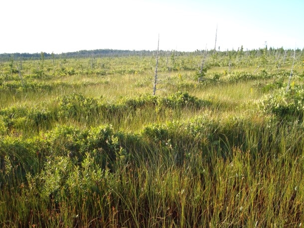
What are “strings” and “flarks”? Understanding and identifying Michigan’s natural communities is facilitated by a broad range of natural-history knowledge. Users will find that the value of this natural community classification will be enriched by the study of Michigan’s climatic influences, surficial geology, hydrology, ecosystem processes, soils, and flora. We provide a glossary of concepts and key terms, such as “strings” and “flarks” (pictured here), that we think are critical for field ecologists and natural community identification. Users should note that this glossary provides definitions for terminology used on this site that are consistent with their usage in this classification and appropriate to their application in Michigan.
- abrasion
- The process of wearing away by friction. This mechanical weathering can be caused by ice, mineral soil (i.e., sand), and snow.
- acidic
- Soil or water having a pH < 7.0, often indicating moderate to low nutrient availability.
- aerated
- Refers to soil that is aerobic, having free molecular oxygen present and available.
- aerobic
- A condition characterized by the presence and availability of free molecular oxygen.
- alkaline
- Soil or water having a pH > 7.0. Equivalent to basic.
- anaerobic
- A condition characterized by the absence of free molecular oxygen.
- annual
- A plant that completes its life cycle in a single growing season. A winter annual germinates in fall, overwinters, and sets seed and dies the following growing season.
- aquatic plant
- A plant that completes its life cycle in water.
- aquifer
- A subterranean formation that contains sufficient saturated permeable material to yield significant quantities of water. Some aquifers release water at the surface in the form of seepages.
- backswamp
- Low-lying wet areas on floodplains, located away from the active channel, and where organic soils accumulate.
- barrens
- In Michigan, a general term sometimes applied to dry savannas, often occurring on extremely acidic sands with low nutrient content and low water-holding capacity.
- barrier-beach lagoon
- A shallow pond or lagoon sheltered from a large lake’s wave energy by a sand or gravel bar that has been deposited by storm waves or nearshore currents.
- basalt
- Volcanic bedrock deposited as lava flows during the Late Precambrian Era. Characterized by heavy, dark, finely crystalline rock rich in iron-bearing mineral. Basalt is treated as a type of volcanic bedrock in this book.
- bedrock
- The solid rock that is exposed at the surface or underlies soil and other unconsolidated material. Within Michigan, there are four major categories of bedrock: limestone, sandstone, granite, and volcanic, although there are also areas of siltstone and shale.
- beech bark disease
- Beech bark disease is a disease complex that was introduced to North America around 1900 and was first detected in Michigan in 2001. The disease results when the bark of beech trees is attacked by the beech scale (Cryptococcus fagisuga) and subsequently invaded and killed by fungi, primarily Nectria coccinea var. faginata, and sometimes N. galligena.
- billabong
- Australian term for a riparian wetland that is periodically flooded by the adjacent stream or river.
- biodiversity (biological diversity)
- The complexity of life at all its levels of organization, including genetic variability within species, species and species interactions, ecological and evolutionary processes, and the distribution across the landscape of species and the natural communities in which they occur.
- bluff
- A high steep bank.
- bog
- An acidic, nutrient-poor, peat-accumulating wetland that is isolated from mineral-rich water sources by deep peat accumulation and therefore receives most of its water and nutrients from precipitation (see ombrotrophic).
- boreal
- Applied to a climate zone with short, cool to mild summers and snowy winters. Also can refer to northern species that occur in this climate.
- bottom
- Low, poorly drained swamp located in a floodplain and formed by the present drainage system and subject to frequent over-the-bank flooding; soil texture is typically finer than that of the levee.
- bottomland
- Low-lying land along a water course.
- brine
- Water saturated with salt.
- brown moss
- A moss species of the family Amblystegiaceae, typically growing in calcium-rich wetlands.
- bryophyte
- A division of plants including mosses, liverworts, and hornworts; these are non-flowering and non-vascular plants.
- buried river mouth (drowned river mouth)
- A bay formed when high Great Lakes water levels flood the lower stretches of a tributary river.
- calcareous
- Composed of or containing calcium carbonate, a mineral with a high pH. Often used to describe alkaline soil, groundwater, or surface water that has been in contact with limestone, dolomite, calcium-rich glacial deposits, or lacustrine sands.
- calciphile (calcicole)
- A plant that is adapted to grow in calcium-rich soils or water, or on calcium-rich rock (i.e., limestone and dolomite). Examples of calciphiles include the sedge Carex viridula and limestone calamint (Clinopodium arkansanum).
- calcium carbonate
- A chemical compound (CaCO3) found in rocks, particularly limestone, the shells of marine organisms and snails, plant ashes, bones, and eggshells. It occurs in different crystal forms in the minerals calcite and aragonite, which largely comprise limestone.
- canopy
- The tallest vegetative layer in a natural community.
- canopy gap
- Openings in the canopy created by the death of a large branch or one or more trees.
- carbonate
- A salt characterized by the presence of the carbonate ion (CO32-). Can refer to minerals and rock that are dominated by the carbonate ion.
- catastrophic fire
- Infrequent stand-killing crown fire.
- characteristic species
- A species strongly associated with a particular natural community type, either as a dominant, a ubiquitous non-dominant component, or as an indicator of that community type.
- circumneutral
- Having a pH around neutral, or 7.0 (in the range of 6.6 to 7.3).
- clay
- A fine-grained and slow draining mineral soil containing more than 40% clay particles, less than 45% sand particles, and less than 40% silt particles; a soil particle smaller than 0.002 mm in diameter.
- cliff
- An exposed, very steep to perpendicular or overhanging face of rock.
- climatic tension zone
- A narrow zone where many species reach the limits of their range due to climatic factors. In Michigan, the climatic tension zone occurs as a band passing through the central portion of the Lower Peninsula.
- coarse-textured
- Soil or landform characterized by large particle size, often sands or gravels.
- cobble
- A naturally rounded or smoothed stone larger than a pebble and smaller than a boulder.
- community structure (physiognomy)
- The spatial arrangement of vegetation within a natural community.
- conglomerate
- A sedimentary rock formed by the cementation of rock fragments varying in size from small pebbles to large boulders. Conglomerates often form in abandoned lake or stream beds.
- conifer
- A gymnosperm of the order Coniferales; any of a large group of cone-bearing trees and shrubs, mostly evergreens.
- connecting river (connecting channel)
- A major river channel linking the Great Lakes (i.e., St. Marys, Detroit, and St. Clair Rivers).
- cove
- A small sheltered inlet or bay.
- cover
- The percentage of area (or “the ground”) that would be covered by a vertical projection of a given vegetation layer, group of plants, or plant species.
- deciduous
- Pertaining to plants that shed their herbaceous tissues after a season’s growth.
- delta
- Fan-shaped areas where stream sediments deposited at the mouth of a river accumulate and create multiple shallow channels, low islands and abandoned meanders that allow for extensive wetland development.
- deposition
- The process of soil particles and organic matter (sediment) being deposited by wind or water.
- depression
- Any relatively sunken part of the earth’s surface surrounded by high ground. Depressions often support wetlands.
- desiccation
- Becoming dried up, typically in reference to soil.
- disjunct
- A plant that is notably distant from its primary distribution or normal growing range. For example, coastal plain marshes in Michigan support numerous plants that are disjunct from the Atlantic and Gulf coastal plains.
- dissolution
- The process that occurs when water passing through soluble bedrock (e.g., limestone or dolomite) produces underground cavities. These cavities reduce support to the above ground and can cause localized collapse of the overlying bedrock.
- distribution
- The geographical extent of a natural community.
- dolomite (dolostone)
- A resistant sedimentary rock with a high content of magnesium-calcium carbonate. Produces calcium and magnesium rich soils with high pH and nutrient availability. Dolomite is treated as a type of limestone bedrock in this book.
- dominant
- A species with the greatest abundance, percent cover, or influence in a natural community or vegetative layer.
- drainage
- Refers to depth, frequency, and duration of periods of water saturation in a soil. Drainage classes range from excessively well-drained for xeric soils and very poorly drained for flooded soils. Soil drainage is affected by soil texture, landscape position, and groundwater fluctuations.
- drought
- A prolonged period of dryness.
- dry
- A soil moisture class. Dry soils are excessively to somewhat excessively drained.
- dry-mesic
- A soil moisture class. Dry-mesic soils are well-drained; water is removed from the soil readily but not rapidly.
- dune
- Landform composed of wind-deposited sands. Most of Michigan’s dunes were formed along the Great Lakes post-glacially, but there are also inland dunes formed during glaciations both in the eastern Upper Peninsula and northern Lower Peninsula.
- dune field
- An area covered by extensive sand dunes.
- Dutch elm disease
- A disease of elms caused by an introduced fungus (Ceratocystis ulmi) and characterized by yellowing of the foliage, defoliation, and death. Following an epidemic in the 1960s, the disease has virtually eliminated American elm as a dominant overstory tree of swamps throughout Michigan.
- ecoregion
- A large area defined by its environmental conditions, especially climate, landform, and soil characteristics where natural community types recur in predictable patterns.
- ecotone
- A transitional zone where characteristics of immediately adjacent ecosystems and natural communities intermingle or intergrade.
- emerald ash borer
- Emerald ash borer (Agrilus planipenis) is a species of invasive beetle that was introduced to southeastern Lower Michigan around 1990. This species infests and kills all species of ash. Emerald ash borer has decimated mature ash trees in southern hardwood swamps, floodplain forests, and upland forests across southern Lower Michigan.
- emergent plant
- A wetland plant whose leaves grow mainly above the water, not floating or submerged. May be temporarily to permanently flooded at the base, while the upper portions of the plant grow erect above the water surface. Broad-leaved cat-tail, bulrushes, and spike-rushes are common emergent plants.
- end moraine (terminal moraine)
- A ridge-like accumulation of unsorted glacial till deposited along the margin of an active glacier. A moraine built at the edge of a glacier.
- ericaceous
- Pertaining to plants of the heath family (Ericaceae).
- erosion
- The process of wearing away by the action of water, wind, or ice.
- escarpment
- A relatively continuous cliff or exposure of bedrock produced by erosion or faulting, breaking the general continuity of more gently sloping land surfaces and usually extending a long distance linearly across the landscape.
- esker
- A long, narrow, often winding ridge of mixed sand and gravel deposited by a glacial meltwater stream flowing through crevasses, holes, and tunnels in a stagnant ice sheet.
- evergreen
- Pertaining to plants having foliage that does not fall at the end of the growing season.
- exfoliation
- A weathering process of bedrock where layers of exposed bedrock fall off.
- extirpation
- Disappearing from a locality or region without becoming extinct; local extinction.
- fen
- A minerotrophic, peat-accumulating wetland that receives water that has been in contact with mineral soils or bedrock. Fens can range from weakly minerotrophic peatlands that are acidic to strongly minerotrophic peatlands that are alkaline.
- fern ally
- A seedless vascular plant that is not a true fern, but like a fern, disperses by shedding spores. Clubmosses and horsetails are common fern allies.
- fern
- Any of a large class of flowerless spore-producing vascular plants with roots, stems, and leaflike fronds.
- fine-textured
- Soil or landform characterized by small particle size, i.e. silts and clays.
- fire regime
- The frequency, intensity, and type of fires that occur in a particular natural community or ecosystem.
- fire-dependent community
- Natural community that depends on fire for maintenance of its species composition and community structure.
- first-order stream
- A stream that does not have any other stream feeding into it. Equivalent to a headwater stream.
- flagged
- A condition in which freezing winds kill branches on the windward side of a tree and the upper branches grow mainly from the leeward side of the tree, like a flag blowing from a flagpole.
- flark
- Elongated and wet depression in patterned peatlands. The long axis of the flark is oriented perpendicular to the direction of topographic contours and water flow.
- floating plant
- A wetland plant with leaves on the surface of the water. Floating leaves neither rise above the surface nor live entirely under the surface. Sweet-scented waterlily is a floating plant.
- flooding
- The hydrologic process whereby the water surface rises above the wetland substrate.
- floodplain
- Nearly level to gently sloping land adjacent to a stream or river channel, shaped by periodic flooding and long-term lateral migration of the stream.
- fluvial landform
- Landforms that are derived from fluvial (stream) processes and occur within floodplains.
- forb
- A generic term for broad-leaved flowering herbaceous plants. A forb is a non-woody plant that is not a graminoid (grass-like) or a fern.
- foredune
- In a coastal sand dune system, the dune closest to the Great Lakes that is strongly influenced by wind and wave action.
- forest
- A tree-dominated upland having at least 60% canopy closure.
- frost heave
- An upthrust of ground caused by freezing of moist soil.
- gabbro
- A coarsely crystalline basic igneous rock within the granite bedrock group. Gabbro is treated as a type of granitic bedrock in this book.
- gap-phase dynamics
- The natural process whereby frequent, small canopy gaps allow for the regeneration of shade-tolerant canopy trees in forested natural communities.
- glacial drift
- Any material (e.g., clay, silt, sand, gravel, stones, and boulders) transported and deposited by glacial ice or meltwater.
- glacial or proglacial lakebed
- The bed of a lake formed between a high land feature and a glacier. Thin clay layers (varves) were deposited annually during the winter on the lake bottom, and often formed thick, flat deposits. Sand was deposited in meltwater streams in the lakebed, typically forming channels. Sand deposits were reworked by waves into beach ridges.
- glacial till
- Unstratified materials carried and deposited directly by a glacier (till does not come from melt water).
- glacier
- A large body of ice moving slowly on a land surface. Over 10,000 years ago, Michigan was covered by glaciers that shaped many of our current landforms and soils.
- glade
- A savanna or open woodland community that occurs on exposed bedrock and thin soils over bedrock.
- gneiss
- A metamorphic foliated bedrock formed from either igneous or sedimentary rocks. Gneiss is treated as a type of granitic bedrock in this book.
- graminoid
- A collective term for grasses and grass-like plants including sedges, bulrushes, spike-rushes, and rushes that are narrow-leaved and herbaceous.
- granite
- A resistant igneous rock that is composed predominantly of feldspar and quartz and weathers slowly to produce acidic, nutrient-poor soils. The term granite is often loosely used to include metamorphic rock types such as gneiss.
- grassland
- An open-canopy, grass-dominated natural community; including prairies, wet prairies, and alvar.
- gravel
- A soil type composed primarily of small rock fragments between 2 mm and 7.6 cm in diameter.
- ground moraine
- Gently sloping, rolling topography formed from material deposited under an active glacier.
- groundwater seepage
- The movement of water from underground to the surface.
- groundwater
- Water occurring below the earth’s surface and the water table in openings in bedrock and soils.
- growing season
- The period of year when plants grow. Approximately, the period between the last frost of spring and the first frost of autumn. The average growing season is longest in southeastern Lower Michigan and shortest in the interior western Upper Peninsula and locally in the interior northern Lower Peninsula.
- growing-season frost
- Ice formed during the growing season when moisture condensing at ground level freezes.
- gypsum
- A sedimentary rock primarily composed of hydrous calcium sulfate [calcium sulfate with water: CaSO4-2(H2O)].
- halite
- Rock salt deposits.
- halophyte
- A terrestrial plant that is adapted to grow in salt-rich conditions.
- hardwood
- A general term used to indicate a broad-leaved, flowering, deciduous tree.
- headwater
- The source of a stream or river. A headwater stream is a first-order stream.
- herb
- A non-woody vascular plant that has no living parts that persist above the ground after the growing season. Includes forbs, ferns, and graminoids.
- hollow
- A generally small, variably sized topographic depression found in peatlands, swamps, or upland forests. Hollows or pits are separated from each other by hummocks or mounds and may form as a result of windthrow in swamps and upland forests and differential decomposition and accumulation of peat in peatlands.
- hummock
- A mound in a peatland or upland community that is separated from other hummocks by hollows or pits. Hummock and hollow microtopography forms as a result of windthrow in swamps and upland forests and differential decomposition and accumulation of peat in peatlands.
- hydric
- A soil moisture class. Hydric soils are very poorly drained and are saturated or inundated long enough during the growing season to develop anaerobic conditions.
- hydrogeomorphic process
- Process involving the formation of land or soil structures by water activity.
- hydrology
- The study of the movement, distribution, and effects of water on the earth’s surface and in the soil.
- hydrophytic
- Adapted to growing in wet conditions.
- ice-contact topography
- Irregular, steep topography found when a glacier stagnates and then retreats. Typical features are kettle lakes, kames, and eskers. Also called kettle-kame or ice-disintegration topography.
- igneous rock
- Rock formed by the cooling and solidification of molten material. In Michigan, igneous rock formed during the Precambrian period. Igneous rock is treated as a type of granitic bedrock in this book.
- impermeable
- Describes soil that does not allowthe movement of water.
- indicator
- A plant species that has a high affinity for a specific natural community or environmental condition.
- inland
- The interior part of Michigan, away from the Great Lakes shoreline.
- interlobate region
- A region of southern Lower Michigan with a diverse assemblage of landforms deposited at the boundaries between large lobes of glacial ice. This area is comprised of coarse-textured end moraines and ice-contact features (eskers and kames) that are bordered by glacial outwash.
- inundated
- Flooded or covered by water, often on a seasonal or periodic basis.
- invasive species
- A species that does not naturally occur in a specific area and whose introduction negatively affects native species and degrades natural communities.
- kame
- A rounded, steep-sided and often isolated hill composed of water-laid sand and gravel deposited by blocks of stagnant ice.
- karst
- Topography that is formed in limestone, dolomite, or gypsum by dissolution and that is characterized by sinkholes, caves, and underground drainage.
- kettle
- A steep-sided depression formed from the delayed melting of a stagnant ice block stranded in glacial outwash. A kettle may or may not be filled with water.
- kettle-kame topography
- See ice-contact topography.
- knob
- A prominent and often rounded isolated hill with steep sides. In Michigan, knobs are often composed of granitic and volcanic bedrock.
- krummholz
- Tree growth-form characterized by stunted and twisted condition and common to tops of escarpments and subarctic or subalpine tree lines. Trees are distorted into a krummholz growth form by branch breakage resulting from heavy snow, thick ice, and extreme winds. In Michigan, krummholz is most common on Isle Royale and the Keweenaw Peninsula.
- lacustrine soils
- Fine sediments (i.e., sands, silts, and clays) deposited in lakes.
- lakeplain (glacial lakeplain)
- A glacial landform formed by large bodies of water, such as the precursors to the Great Lakes, and comprised of low, flat areas formed by the settling of lacustrine sediments on the bottom of the former lakes and higher sandy ridges formed by ancient beaches.
- landform
- A terrain feature that has a definable shape and composition. In Michigan, landforms are often of glacial origin, including moraines, outwash channels, outwash plains, kames, and lakeplains. Other landforms of more recent origin include floodplains, and along the Great Lakes shoreline, dune complexes, beaches, and eroding bluffs.
- landscape setting
- The characteristics of the area surrounding a natural community including topography, natural disturbance factors, and landcover.
- landslide
- The downward movement of a large mass of earth or rocks from a steep slope or cliff.
- lateral flow
- The hydrologic process of (surface) water moving through saturated organic soils in peatlands.
- lens
- A banding of soil particles occurring in a soil profile (i.e., clay lens).
- levee
- A relatively high feature located parallel to the margin of a river channel, where coarse sediment is deposited by fast-moving floodwaters. In contrast to other parts of the floodplain, levees have coarser soil texture and are further above the water table, resulting in better soil drainage and aeration.
- lichens
- A group of non-vascular plants consisting of a symbiotic association of algae and fungi. Occurs in three growth forms: fruticose (upright), foliose (leafy), and crustose (thin crusts).
- limestone
- A sedimentary calcareous rock composed primarily of calcium carbonate or calcite. Produces calcium-rich soils with high pH and nutrient availability.
- liverworts
- Small non-vascular spore-producing plants in the class Hepaticae. (Related to mosses, but differing from them in certain structural and reproductive characteristics.)
- loam
- A soil consisting of a mixture of varying proportions of sand, silt, and clay. Loam soils contain 23 to 52% sand, 28 to 50% silt, and 7 to 27% clay. Loams are typically fine- to medium-textured (with moderate water holding capacity and moderate to high nutrient availability).
- lowland
- Wetland.
- low shrub
- A shrub that is typically less than one meter (39 in) in height.
- magnesium carbonate
- A carbonate of magnesium; MgCO3.
- marl
- A calcium-carbonate precipitate that forms through the metabolic activity of algae growing in water rich in calcium and magnesium carbonates. Marl is usually a fine, wet silky- textured soil, white to light gray in color, which may also contain clay, silt, and sand.
- marsh
- A wetland dominated by herbaceous, often graminoid vegetation and characterized by inundated to saturated soils.
- matrix system
- A natural community type that is dominant in the landscape and often plays the dominant role in landscape processes. Characterized by broad ecological amplitude, occurring across a wide range of soil and bedrock types, slopes, slope aspects, and landscape positions. Covering hundreds to thousands of acres.
- meander-scar swamp
- Swamp located where a section of stream channel has been abandoned as the stream meanders. Abandoned meanders are characterized by groundwater seepage that saturates the organic soils.
- medium-textured
- Soil or landform characterized by intermediate particle size.
- mesic (moist)
- A soil moisture class. Mesic soils are well drained and moderately well drained. Mesic soil conditions are characterized by adequate moisture availability for plants throughout the growing season.
- metamorphic rock
- Rock that has been changed by pressure or heat. In Michigan, metamorphic rock formed from igneous and sedimentary rock during the Precambrian period. Metamorphic rock is treated broadly as part of granitic bedrock in this book.
- mineral soil
- Soil consisting primarily of, and having its properties determined by, mineral particles.
- mineral nutrient
- A chemical element essential to a plant’s growth and survival that occurs in the soil and is absorbed through the plant’s roots. Primary mineral nutrients are nitrogen (N), phosphorus (P), and potassium (K). See nutrient.
- mineral-rich
- Characterized by high mineral availability for plants.
- minerotrophic
- A term describing wetlands (typically peatlands) that receive minerals and nutrients through contact with either surface water or groundwater sources that have been in contact with mineral soils or bedrock. Compare to ombrotrophic.
- moat
- Area of shallow water surrounding a natural community, especially a bog.
- moraine
- A glacial landform deposited either at the stagnating terminal margin of ice, producing a large hill (end moraine) or deposited from a broad ice sheet that melts in place, forming a rolling plain (ground moraine). Moraines are characterized by an unsorted mixture of sand, silt, and clay soil particles, the proportion being determined by the sediments that the glacier was carrying at the time of deposition.
- moss
- A small, non-vascular, chlorophyll-containing, spore-producing plant in the class Musci. Mosses include the “true” or “brown” mosses, as well as the peat mosses or sphagnum mosses.
- muck
- A dark-colored, unconsolidated organic soil consisting of highly decomposed plant remains where the decomposition has progressed to a point where the contributing plant species are not recognizable. Also called sapric peat.
- native
- A species that occurs naturally in a specific area, and is usually adapted to local or regional ecological conditions. Indigenous.
- natural community
- An assemblage of interacting plants, animals, and other organisms that repeatedly occurs under similar environmental conditions across the landscape and is predominantly structured by natural processes rather than modern anthropogenic disturbances.
- natural processes
- Dynamic factors that influence the species composition, structure, and successional pathways of natural communities (e.g., fire, flooding, groundwater seepage, and windthrow).
- neutral
- Having a pH of 7.0.
- Niagaran Escarpment and Niagaran Cuesta
- Exposed, steep ridge of the resistant marine carbonate rocks limestone and dolomite from the Ordovician and Silurian Periods. The gently sloping bedrock plain above the escarpment is called the Niagaran Cuestra, which extends along the shorelines of northern Lakes Huron and Michigan.
- non-mineral nutrient
- A chemical element essential to a plant’s growth and survival that occurs in the air and the water. The non-mineral nutrients are hydrogen (H), oxygen (O), and carbon (C). See nutrient.
- northern hardwoods
- A general term used to indicate several broad-leaved, deciduous tree species prevalent in northern Michigan, especially beech, sugar maple, yellow birch, and basswood.
- northern
- Occurring north of the climatic tension zone.
- nutrient-poor
- Low nutrient availability for plants.
- nutrient-rich
- High nutrient availability for plants.
- nutrient
- A chemical element essential to a plant’s growth and survival.
- old-growth
- A late-successional stage in forest development exhibiting characteristic structural features, species assemblages, and ecological processes.
- ombrotrophic
- A term describing wetlands (peatlands) that receive all or most of their water and nutrients from precipitation. Compare to minerotrophic.
- open embayment
- Curving sections of Great Lakes shoreline open to strong lake winds and currents, but that offer enough protection that emergent plants can often establish and survive.
- organic soils
- Soil composed of primarily organic matter rather than mineral materials.
- outwash channel
- A glacial landform characterized as a relatively narrow, flat plain deposited by a glacial river. Soils are usually well-sorted sands, sometimes now overlain by accumulated peat in wetland environments.
- outwash plain
- A glacial landform characterized as a broad, flat to slightly rolling plain deposited by large volumes of glacial meltwater. Soils are usually well-sorted sands.
- outwash
- Glacial drift composed of sand and gravel that has been transported, reworked, sorted, and stratified by glacial meltwater flowing off the glacier.
- over-the-bank flooding
- Flooding regime characteristic of floodplains where flood water seasonally inundates the land adjacent to the river or stream.
- oxbow
- An abandoned river channel that has been cut off from the river by lateral channel migration across the floodplain. Oxbows often develop into swamp or marsh inclusions within the floodplain.
- palustrine
- Wetlands; Ecosystems that are saturated or inundated with water for varying periods during the growing season and characterized by hydrophytic vegetation, soils, and natural communities that have developed under these conditions.
- peat
- : An organic soil composed of partially decomposed organic material that is formed under saturated and anaerobic conditions. Common peat forming plants are Sphagnum mosses and wetland grasses and sedges (graminoids).
- peatland
- A wetland that develops where drainage is poor, precipitation is retained, decomposition of organic matter is slow, and peat accumulates.
- pH
- A measure of acidity or basicity, ranging from 0 (strongly acidic) to 14 (strongly basic or alkaline) on a logarithmic scale, with 7.0 being neutral.
- physiography
- Physical geography, a subfield of geography that studies patterns and processes of the environment.
- physiognomy
- Botanically defined as life form (e.g., tree, shrub, and herb). Ecologically defined as the structural characteristics and spatial arrangement of vegetation within a natural community.
- pit
- see hollow.
- pitted outwash plain
- An outwash plain characterized by numerous kettle depressions.
- post-glacial uplift (post-glacial rebound or isostatic rebound)
- Gradual rise in land surface that results from the removal of the weight of glacial ice.
- prairie
- Native grassland dominated by warm-season grasses and herbs with no or few trees.
- primary nutrient
- A major, limiting nutrient used in large amounts for a plant’s growth and survival. These are nitrogen (N), phosphorus (P), and potassium (K). Primary nutrients often occur at very low concentrations in anaerobic habitats such as peatlands (e.g., bogs and fens). See nutrient.
- primary producer
- Organism in an ecosystem that produces biomass from inorganic compounds. In almost all cases these are photosynthetically active organisms (i.e., plants, cyanobacteria and a number of other unicellular organisms).
- primary
- Occurring on bedrock, cobble, or exposed mineral soils and characterized by little to no soil development.
- protected embayment
- Deep shoreline indentations cut into resistant upland shoreline that provide significant protection from wind and wave energy.
- quartzite
- A compact granular metamorphic rock composed of quartz and derived from sandstone. Quartzite is treated as a type of granitic bedrock in this book.
- regeneration
- Tree saplings occurring in the understory layer of forested natural communities.
- resistant
- Describing bedrock that weathers or erodes very slowly.
- rhyolite
- Fine-grained, light-colored (reddish) volcanic bedrock low in iron and magnesium-bearing minerals. Highly resistant to erosion and more acidic than other volcanic bedrock in Michigan.
- rich
- Describes environments where nutrients are abundant and/or communities with high species diversity.
- ridge
- A raised area of land, often linear.
- ruderal species
- Weedy species, including both native and non-native plants.
- saline soil
- A soil containing sufficient dissolved salts to influence vegetation.
- sand
- A soil particle between 0.05 and 2.0 mm in diameter, the largest size class of particles that make up soil. Sand soil contains at least 85% sand particles and is gritty to the touch with individual grains visible to the naked eye.
- sand burial
- The nearshore process in which vegetation is buried by wind-blown sands.
- sandplain
- A flat area of glacial lakeplain or outwash dominated by sandy soils.
- sand spit
- A small point or narrow embankment of land, formed from sand deposited by longshore drifting, and having one end connected to the mainland and the other terminating in open water.
- sand-spit embayment
- Shallow embayments formed behind sand spits that form along gently sloping and curving sections of shoreline where sand transport parallels the shore. The spits are exposed to both wave activity and overwash, but provide good protection from wind and waves on the landward side where extensive wetlands often develop.
- sandstone
- A sedimentary rock composed of grains of sand deposited by water or wind and bound together by a cement of silica, carbonate, or other minerals. In Michigan, exposed sandstone bedrock features are formed from the Copper Harbor Conglomerate, Jacobsville Sandstone, Nonesuch Shale and Freda Formations, Munising Sandstone, Marshall Sandstone, and Eaton Sandstone.
- sapric peat
- See muck.
- saturated
- Constantly filled with water, referring to poorly drained soils that are perennially wet.
- savanna
- Savannas are grasslands interspersed with open-grown scattered or grouped trees forming a partial canopy between 5 and 60 percent.
- schist
- A metamorphic crystalline rock that has closely foliated structure and can be split along approximately parallel planes. Schist is treated as a type of granitic bedrock in this book.
- scour
- The powerful and concentrated clearing and digging action of flowing air, water, or ice.
- secondary nutrient
- A chemical element essential to a plant’s growth and survival that is used by plants in lesser quantity than a primary nutrient and is typically not limiting. Examples are calcium (Ca), magnesium (Mg), and sulfur (S). Secondary nutrients may be present at high concentrations in habitats such as fens that support low concentrations of primary nutrients. See nutrient and primary nutrient.
- second-order stream
- A stream that is formed when two first-order streams come together.
- sedge
- A grass-like herbaceous plant with narrow leaves of the family Cyperaceae, especially of the genus Carex.
- sediment
- Material deposited by water, wind, or glaciers.
- sedimentary rocks
- Rocks formed by consolidation of sediments deposited by wind or water. In Michigan sedimentary rocks were formed during the Paleozoic period and include sandstone, shale, limestone, and dolomite.
- seep
- A small area of groundwater discharge in a diffuse flow.
- seepage
- The movement of water through the soil especially the diffuse slow oozing out of groundwater onto the earth’s surface. Seepage transports nutrients to and through wetlands from soil and bedrock source areas.
- shade-tolerant
- A species tolerant of shade conditions (e.g., sugar maple, beech, and hemlock).
- shale
- Sedimentary rock formed by the hardening of clay, silty clay, or silty clay loam deposits and having the tendency to split into thin layers.
- shrub
- A woody perennial plant that differs from a tree in its short stature and typically multi-stem growth form. A shrub is typically less than 5 meters tall and branches several times at or near its base.
- silt
- A fine-grained mineral soil intermediate in size between sand and clay. Silt particles range between 0.05 and 0.002 mm. Silt is smooth and slippery when wet and is typically carried in or deposited by moving water.
- sinkhole
- A depression in the landscape caused by the dissolution and collapse of subsurface bedrock.
- slope
- The inclination of the land surface from horizontal.
- sloughing
- Erosion of bedrock due to weathering or large areas of mineral soils due to groundwater seepage.
- softwater
- Water that lacks dissolved minerals, especially calcium.
- soil chemistry
- The chemical property of soil, measured by evaluating pH and ranging from acidic to basic.
- soil development
- The process of physical and chemical alteration of parent material into mineral soil under the influence of climate, hydrology, organisms, and time. Refers specifically to development of mineral soils.
- soil moisture class
- The descriptive terms applied to natural communities in distinguishing soil moisture based on frequency and duration of hydrologic conditions and to describe relative soil moisture availability. The classes are based on runoff, permeability, and internal drainage characteristics. The classes are xeric, dry, dry-mesic, mesic, wet-mesic, and hydric.
- soil texture
- The relative proportions of the various soil particles (sand, silt, and clay) in a soil. Three broadly defined categories include coarse-textured, medium-textured, and fine-textured.
- soil
- A dynamic natural body on the surface of the earth in which plants grow, composed of mineral and organic materials and organisms.
- southern
- Occurring south of the climatic tension zone.
- sp.
- Species singular.
- Sphagnum moss
- A member of the moss genus Sphagnum, also known as peat moss.
- spp
- Species plural.
- spring thaw
- The period when ice and snow melts in the spring.
- ssp
- Subspecies.
- state rank
- The status or rarity of the natural community type in Michigan. State ranks are based on the estimated number of high-quality occurrences of the natural community type, estimated area, geographic range, estimated number of adequately protected examples, and threats to the natural community type.
- storm wave
- High energy wave from the Great Lakes that influences shoreline processes.
- string
- Elevated, narrow, and often linear peat ridge in patterned peatlands. The long axis of the string is oriented perpendicular to the direction of contours and water flow.
- submergent plant
- A wetland or aquatic plant that grows completely beneath the water surface. Coontail is a submergent plant.
- subsection
- An ecoregional unit within Michigan’s hierarchical landscape classification system (Albert 1995) with similar sub-regional climate, surficial geology, lithology, geomorphic processes, soils groups, and potential natural community types.
- substrate
- The surface on which vegetation grows and natural communities develop (i.e., mineral soil, organic soil, and bedrock).
- subterranean
- Occurring beneath the surface of the earth.
- succession
- The natural and directional changes in species composition within a community over time.
- surface fire
- Low-intensity fire that burns the litter and understory layers.
- surface water
- Water occurring on the surface of the earth.
- swale
- An area of land lower than its surroundings, typically elongate and often lower than the water table, thus retaining water at least seasonally.
- swamp
- A forested or shrub wetland area whose soil, typically organic, is permanently or periodically saturated or inundated or seasonally inundated.
- tall shrub
- A shrub that is typically greater than one meter (39 in) in height.
- terrace
- Elevated portions of fluvial sediments in floodplains. Low terraces may occasionally be flooded while high terraces remain above the flood zone.
- terrestrial
- Upland ecosystem that has xeric to mesic soils with plants adapted to these growing conditions.
- third-order river
- River or stream that is formed when two second-order streams come together and is characterized by periodic over-the-bank flooding and cycles of erosion and deposition.
- tombolo
- Tombolos form when bedrock islands are connected to the mainland by current-deposited sands. The embayment created on the leeward side of the tombolo provides protection from Great Lakes wave action where wetlands can develop.
- topography
- The configuration of a surface including the position and elevation of its natural features.
- tree
- A woody perennial plant, usually having one principal stem (typically unbranched at the base) and exceeding 5 meters high.
- trophic level
- One of the hierarchical strata of a food web of organisms.
- upland
- An ecosystem that has xeric to mesic soils and/or exposed bedrock and supports plants adapted to these growing conditions.
- vascular plant
- A plant with a vascular system; includes trees, shrubs, and herbs, but not bryophytes, lichens, or algae. Vascular plants have a structural system of tissue (xylem and phloem) that conducts water and soluble nutrients.
- vernal pool
- Ephemeral pools that hold water, typically in the spring, after which they dry up; such pools often have a unique flora and fauna and are especially important for amphibians.
- vesicle
- Small cavities in volcanic bedrock formed when surface lava flows quickly cooled and bubbles of enclosed gas were entrapped.
- vine
- A plant which climbs or sprawls by means of twining or tendrils; also a plant which trails or creeps extensively along the ground. Vines can be woody or herbaceous.
- volcanic bedrock
- Late Precambrian bedrock formed following periods of extensive surface volcanic activity and from vast sheets of flowing lava, interbedded with thin layers of conglomerate, which consisted of both pebbles and cobbles. Volcanic bedrocks in Michigan include basalt, rhyolite, and volcanic conglomerate.
- volcanic conglomerate
- Rift-filling sedimentary rocks deposited by water during a period of reduced volcanic activity. Composed of rounded fragments varying from small pebbles to large boulders in a cement deposited from the margins of the basin by streams eroding earlier lava flows. Typically containing more than 50% volcanic material. Volcanic conglomerate is treated as a type of volcanic bedrock in this book.
- water table
- The upper surface or limit of groundwater, or that level below which the soil is saturated with water. The water table can fluctuate from season to season and year to year with climatic variations. Most uplands have a water table well below the ground surface, whereas in wetlands the water table is often at or above the ground surface.
- water track
- Area in peatland characterized by directional flow of minerotrophic water and often marked by distinct string and flark patterning.
- water-holding capacity (water-retaining capacity)
- The capacity for soil to hold moisture.
- weathering
- The physical and chemical process of breaking down the original complex molecules of primary minerals in parent material (e.g., bedrock, till) and soil.
- wet prairie
- Herbaceous wetland dominated by grasses, sedges, and forbs occurring on saturated to seasonally inundated mineral soils with variable organic content.
- wet
- A soil moisture class. Wet soils are very poorly drained; water is removed from the soil so slowly that the water table is at or above the surface most of the time.
- wetland
- An ecosystem that is saturated or inundated with water for varying periods during the growing season and characterized by hydrophytic vegetation and soils and natural communities that have developed under saturated or inundated conditions.
- wet-mesic
- A soil moisture class. Wet-mesic soils are somewhat poorly drained to poorly drained. The soils are wet at shallow depths for significant periods during the growing season.
- windthrow
- The uprooting or breakage of trees cause by wind and generating canopy gaps in forested systems. Also called blowdown.
- woodland
- A woodland is a natural community that is intermediate between a savanna and a forest, usually having a canopy between 50 and 80 percent.
- xeric
- A soil moisture class. Xeric soils are excessively drained and characterized by a lack of moisture. Water is removed from the soil very rapidly and extremely dry conditions prevail.
Citation
Cohen, J.G., M.A. Kost, B.S. Slaughter, D.A. Albert, J.M. Lincoln, A.P. Kortenhoven, C.M. Wilton, H.D. Enander, and K.M. Korroch. 2020. Michigan Natural Community Classification [web application]. Michigan Natural Features Inventory, Michigan State University Extension, Lansing, Michigan. Available https://mnfi.anr.msu.edu/communities/classification. (Accessed: April 29, 2024).