

Clay Bluffs
Overview
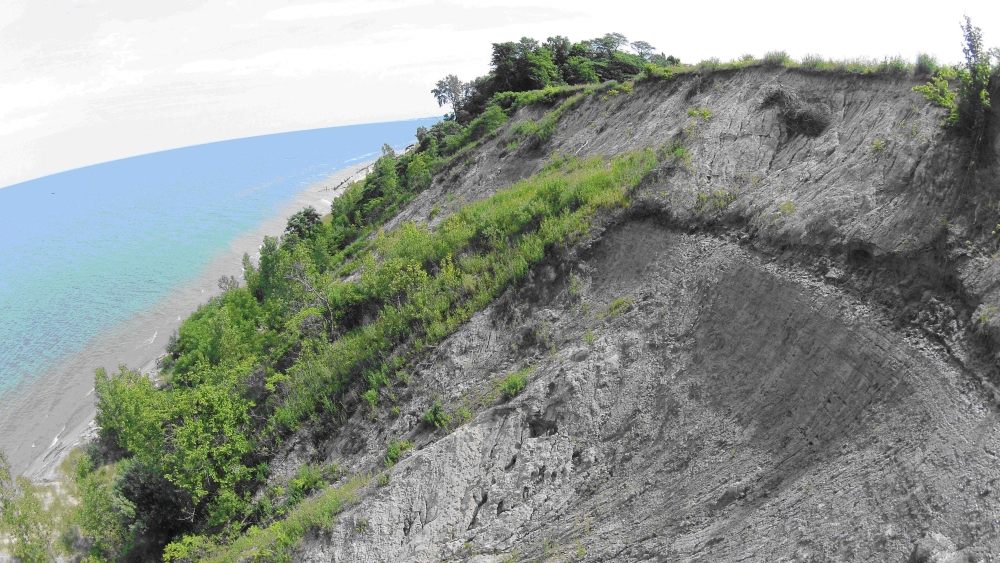
Clay bluffs is a forb-, graminoid-, and shrub-dominated and erosion-dependent community that occurs infrequently on steep to near-vertical clay slopes along the shorelines of Lake Michigan and Lake Superior. Clay bluffs is less commonly found localized along eroding banks of rivers and streams that form ravines through clay soils and drain into these Great Lakes. Clay bluffs ranges from three to 30 meters (10 to 100 feet) tall. Clay bluffs is a dynamic system with active sloughing occurring following frost heave and spring thaw and vegetation varying from year to year. Clay bluffs occurs on alkaline clays that are locally exposed following these landslide events. Species composition and vegetative structure of clay bluffs is patterned by sloughing of clay slopes due to groundwater seepage. Clay bluffs is characterized by sparse forb, graminoid, and low shrub cover, dense patches of tall shrubs, and scattered and stunted overstory trees.
Rank
Global Rank: GNR - Not ranked
State Rank: S2 - Imperiled
Landscape Context
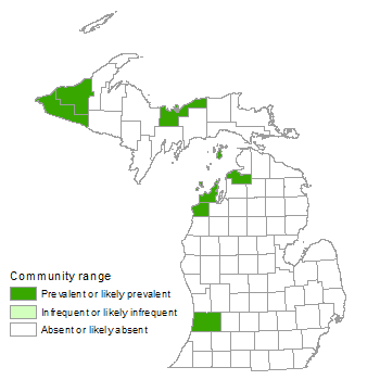
Clay bluffs occurs infrequently along the Lake Michigan and Lake Superior shoreline and is less commonly found localized along banks of rivers and streams that form deep ravines through clay soils and drain into these Great Lakes (Albert 1995, Epstein et al. 2002, NatureServe 2012). Occurrences of clay bluffs have been documented along the Lake Michigan shoreline in southwestern and northwestern Lower Michigan and also along the Lake Superior shoreline in the far western Upper Peninsula in the Porcupine Mountains Wilderness State Park and in the east-central Upper Peninsula in the Pictured Rocks National Lakeshore (Fuller 2009, Cohen 2010, Hop et al. 2010, Cohen and Penskar 2011). Several islands within Lake Michigan also support clay bluffs (e.g., South Fox Island, North Manitou Island, and South Manitou Island). Clay bluffs typically occurs along shorelines dominated by sand and gravel beach lakeward and mesic northern forest inland. Within the Pictured Rocks National Lakeshore and along the Great Lakes islands and the northeastern shore of Lake Michigan, clay bluffs are nested within large perched dune complexes (Albert 2000, Hop et al. 2010). Within the Porcupine Mountains Wilderness State Park, the clay bluffs occur along a six-mile stretch of Lake Superior shoreline with an extensive block of old-growth mesic northern forest occurring inland from the clay bluffs and sand and gravel beach, sandstone cobble shore, and volcanic cobble shore occurring along the shoreline (Cohen 2010). Along the Lake Michigan shoreline in southwestern Lower Michigan, the adjacent mesic northern forest has been extremely fragmented by residential development (Cohen and Penskar 2011).
Soils
Clay bluffs occurs on alkaline clays that are locally exposed following sloughing events. Clays include red and gray clays and often are gravelly or sandy with wind-borne sands from the adjacent shoreline mixing with the clays. In addition, clays along the lower margin of seepage bluffs often ooze onto the upper margin of the adjacent sand and gravel beach.
Natural Processes
Clay bluffs is an erosion-prone community that occurs along steep to nearly vertical slopes above Lake Superior and Lake Michigan and along the banks of rivers and streams that drain into these Great Lakes. Clay bluffs occurs as a narrow linear feature that is inherently rare and typically isolated from other occurrences (Fuller 2009). Clay bluffs ranges from three to 30 meters (10 to 100 feet) tall. Infrequent landslides result in scattered areas of exposed clays. Clay bluffs is also characterized by very active seepage, with a high portion of the slopes percolating groundwater, especially during the rapid spring discharge. Groundwater seepage is a destabilizing factor within these systems, causing bluff erosion and the sloughing or slumping of the clay slopes (Chase et al. 1999, Chase and Kehew 2000). Clay bluffs is a dynamic system with active sloughing typically occurring following frost heave, spring thaw, and winter storm events and vegetation varying from year to year. It is thought that periods of high groundwater movement are correlated with large erosion events along clay bluffs and that when water tables are low and groundwater movement is reduced, woody species encroachment occurs as the bluff faces become drier (Chase et al. 1999, Fuller 2009). In addition to groundwater, wind and waves also cause erosion, especially along low bluffs and the toe slopes of bluffs (Cowles 1901, Jibson et al. 1994, Chase et al. 1999, Brown et al. 2005, Swenson et al. 2006, Fuller 2009).
Vegetation
Dominant species and community structure vary regionally and from year to year depending on the extent of bluff erosion. The clay bluffs are characterized by areas of recently exposed clay following slumping or landslide with sparse vegetation and areas with dense shrub cover on more stabilized slopes. Due to the frequency of disturbance and the shifting exposure of clay substrate, ruderal species, both native and non-native, are common within clay bluffs (NatureServe 2012). Vegetation is typically absent where the clays have dried and hardened (Cowles 1901). Weeping bluffs (Epstein et al. 2002) or areas of active seepage tend to support species typically associated with alkaline wetlands and a higher diversity of species.
For information about plant species, visit the Michigan Flora website.
Plant Lists
Graminoids
- marram grass (Ammophila breviligulata)
- golden-fruited sedge (Carex aurea)
- rushes (Juncus brachycephalus, J. canadensis, J. tenuis, and J. torreyi)
- green bulrush (Scirpus atrovirens)
Forbs
- fireweed (Chamerion angustifolium)
- common boneset (Eupatorium perfoliatum)
- grass-leaved goldenrod (Euthamia graminifolia)
- wild strawberry (Fragaria virginiana)
- small fringed gentian (Gentianopsis virgata)
- jewelweed (Impatiens capensis)
- great blue lobelia (Lobelia siphilitica)
- grass-of-Parnassus (Parnassia glauca)
- goldenrods (Solidago canadensis, S. nemoralis, S. rugosa, and S. uliginosa)
- side-flowering aster (Symphyotrichum lateriflorum)
Fern Allies
- common horsetail (Equisetum arvense)
- scouring rush (Equisetum hyemale)
- variegated scouring rush (Equisetum variegatum)
Shrubs
- tag alder (Alnus incana)
- red-osier dogwood (Cornus sericea)
- Kalm’s St. John’s-wort (Hypericum kalmianum)
- pin cherry (Prunus pensylvanica)
- choke cherry (Prunus virginiana)
- staghorn sumac (Rhus typhina)
- wild black currant (Ribes americanum)
- willows (Salix myricoides and others)
- soapberry (Shepherdia canadensis)
Trees
- sugar maple (Acer saccharum)
- paper birch (Betula papyrifera)
- white ash (Fraxinus americana)
- green ash (Fraxinus pennsylvanica)
- red-cedar (Juniperus virginiana)
- tulip tree (Liriodendron tulipifera)
- ironwood (Ostrya virginiana)
- cottonwood (Populus deltoides)
- quaking aspen (Populus tremuloides)
- mountain-ash (Sorbus decora)
- northern white-cedar (Thuja occidentalis)
- basswood (Tilia americana)
- hemlock (Tsuga canadensis)
Noteworthy Animals
Further research is needed to determine what animal species rely on this unique habitat.
Rare Plants
None recorded to date.
Rare Animals
None recorded to date.
Biodiversity Management Considerations
The primary management recommendation for clay bluffs is to maintain a buffer of natural communities to reduce the risk of altering the hydrology and introducing non-native invasive species. Maintaining a mature, unfragmented forested buffer around clay bluffs may help limit the local seed source for invasive species distributed by wind or birds and reduce the potential for impacts to groundwater and surface water hydrology. Clay bluffs is characterized by areas of recently exposed clay following landslides. The frequent sloughing and exposure of mineral soils makes this system prone to invasion by weedy native and non-native species. The proximity of this system to the Great Lakes shoreline and along river banks makes it susceptible to excessive foot traffic, which can increase erosion and invasive species introduction. In addition, the inherent characteristic of clay bluffs as narrow and linear features with a high proportion of edge increases its vulnerability to invasive species (Fuller 2009).
Variation
Clay bluffs occur infrequently along the Lake Michigan and Lake Superior shoreline and are less commonly found localized along banks of rivers and streams that form ravines through clay soils and drain into these Great Lakes (Epstein et al. 2002). Clay bluffs have been documented along the Lake Michigan shoreline in southwestern and northwestern Lower Michigan and also along the Lake Superior shoreline in the far western Upper Peninsula in the Porcupine Mountains Wilderness State Park and in the eastern/central Upper Peninsula in the Pictured Rocks National Lakeshore. Several islands within Lake Michigan also support clay bluffs. Further research is needed to evaluate the regional variability of this system and characterize the shoreline versus inland clay bluffs.
Similar Natural Communities
Places to Visit
- Porcupine Mountains Clay Bluffs, Porcupine Mountains Wilderness State Park, Gogebic Co.
- North Manitou Island, Sleeping Bear Dunes National Lakeshore, Leelanau Co.
- Sleeping Bear Dunes, Sleeping Bear Dunes National Lakeshore, Leelanau Co.
- Wau-Ke-Na, William Erby Smith Preserve, Southwest Michigan Land Conservancy, Allegan Co.
Relevant Literature
- Albert, D.A. 1995. Regional landscape ecosystems of Michigan, Minnesota, and Wisconsin: A working map and classification. USDA, Forest Service, North Central Forest Experiment Station, St. Paul, MN.
- Albert, D.A. 2000. Borne of the wind: An introduction to the ecology of Michigan sand dunes. Michigan Natural Features Inventory, Lansing, MI. 63 pp.
- Brown, E.A., C.H. Wu, D.M. Mickelson, and T.B. Edil. 2005. Factors controlling rates of bluff recession at two sites on Lake Michigan. Journal of Great Lakes Research 31: 306-321.
- Chase, R.B., A.E. Kehew, and W. William. 1999. The destabilizing influences of perched ground water in shoreline bluffs composed of heterogeneous glacial materials. Geological Society of America Abstracts with Programs 31 (7).
- Chase, R.B., and A.E. Kehew. 2000. Potential stabilization of Great Lakes shoreline bluffs by removal of ground water. Geological Society of America Abstracts with Programs 32 (7).
- Cohen, J.G. 2010. Ecological Community Field Survey Form: Clay Seepage Bluffs, Porcupine Mountains. Michigan Natural Features Inventory, Lansing, MI. 4 pp.
- Cohen, J.G., and M.R. Penskar. 2011. Ecological Community Field Survey Form: Clay Seepage Bluffs, Wau-Ke-Na. Michigan Natural Features Inventory, Lansing, MI. 2 pp.
- Cowles, H.C. 1901. The physiographic ecology of Chicago and vicinity; A study of the origin, development, and classification of plant societies. Botanical Gazette 31(3): 145-182.
- Epstein, E.J., E.J. Judziewicz, and E.A. Spencer. 2002. Wisconsin Natural Community Abstracts. Department of Natural Resources, Bureau of Endangered Resources, Madison, WI. 15 pp.
- Faber-Langendoen, D., ed. 2001. Plant communities of the Midwest: Classification in an ecological context. Association for Biodiversity Information, Arlington, VA. 61 pp. + appendix (705 pp.).
- Fuller, N. 2009. Clay Seepage Bluffs: Conservation and Management of a Rare and Unusual Natural Community. Western Michigan University, Kalamazoo, MI. 33 pp.
- Hop, K., S. Menard, J. Drake, S. Lubinksi, and J. Dieck. 2010. National Park Service Vegetation Inventory Program: Pictured Rocks National Lakeshore, Michigan. Natural Resource Report NPS/GLKN/NRR-2010/201. National Park Service, Fort Collins, CO. 358 pp.
- Jibson, R.W., J.K. Odum, and J.M. Staude. 1994. Rates and processes of bluff recession along the Lake Michigan Shoreline in Illinois. Journal of Great Lakes Research 20: 135-152.
- Martinus, W. 2007. Natural Features Inventory, Wau-Ke-Na. Portage, MI: Southwest Michigan Land Conservancy.
- NatureServe. 2012. NatureServe Explorer: An online encyclopedia of life [Web application]. Version 7.1. NatureServe, Arlington, VA. Available http://www.natureserve.org/explorer. (Accessed: May 22, 2012.)
- Swenson, M.J., C.H. Chin, T.B. Edil, and D.M. Mickelson. 2006. Bluff recession rates and wave impact along the Wisconsin coast of Lake Superior. Journal of Great Lakes Research 32(3): 512-530.
Citation
Cohen, J.G., M.A. Kost, B.S. Slaughter, D.A. Albert, J.M. Lincoln, A.P. Kortenhoven, C.M. Wilton, H.D. Enander, and K.M. Korroch. 2020. Michigan Natural Community Classification [web application]. Michigan Natural Features Inventory, Michigan State University Extension, Lansing, Michigan. Available https://mnfi.anr.msu.edu/communities/classification. (Accessed: April 18, 2024).
Kost, M.A., D.A. Albert, J.G. Cohen, B.S. Slaughter, R.K. Schillo, C.R. Weber, and K.A. Chapman. 2007. Natural Communities of Michigan: Classification and Description. Michigan Natural Features Inventory, Report No. 2007-21, Lansing, MI.